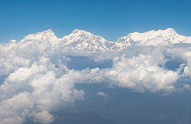
Ngadi Chuli (also known as Peak 29, Dakura, Dakum, or Dunapurna) is a mountain in the Mansiri Himal (or Manaslu Himal), also known as the Gurkha Massif, in Nepal. With an elevation of 7,871 metres (25,823 ft) above sea level, it is the 20th-highest mountain on Earth.
Features
Flanked by Manaslu to the north and Himalchuli to the southeast, Ngadi Chuli is the middlemost and third-highest mountain of the massif. Though shorter and somewhat rounder than its immediate neighbors when viewed from the more common eastern approaches, it is difficult to access due to snow danger and being flanked by active glaciers in all directions. The steep western side, recessed behind outlying peaks and glacial valleys, rises over 3,200 metres (10,500 ft) above the Thulagi glacier. It is crowned by a steep, technical rock headwall with five summits across its length; only the highest of these is named.
Climbing history
Despite its top 20 height, Ngadi Chuli has only been climbed once or twice. The probable first ascent occurred in 1970, when Hiroshi Watanabe and Sherpa Lhakpa Tsering, members of a Japanese expedition, climbed the east ridge and face. They left their camp V, at about 7,500 metres, for a summit attempt. About 70 m below the summit they disappeared out of sight for nearly two hours at 1:15 PM. On their return, after descending a difficult snow ridge, they suffered a fatal fall down an ice wall, from c. 7,600 m nearly down to camp 4 at 6,900 m, where their climbing partners observed their fall. Neither their camera nor Watanabe's ice-ax, to which pennants would have been attached had they reached the summit, survived the fall, so that no conclusive evidence that they reached the summit has ever been found. In order to achieve a confirmed ascent of the mountain, the Japanese organized three more expeditions, in 1974, 1975 and 1978, but these all failed, with the last of these incurring the avalanche deaths of three climbers on the southwestern side of the mountain.
The first confirmed ascent was in 1979 by the Polish climbers Ryszard Gajewski and Maciej Pawlikowski via the West buttress, involving some class V rock climbing at great height.
A British Army Mountaineering Association expedition attempted Peak 29 in the post-monsoon 1982 season. Adverse weather and logistical problems caused by the Falklands War, however, prevented the expedition from climbing above 20,000 feet (6,100 m).
As of 2014, no further attempts have been made on the mountain since the British expedition in 1982.
Timeline
- 1961 First reconnaissance by Japanese climbers.
- 1969 Third Japanese attempt reached 7350 m.
- 1970 Probable first ascent, via the east ridge and face.
- 1978 Three climbers die in an avalanche during the seventh Japanese attempt.
- 1979 First confirmed ascent, by a Polish expedition.
References
- "Peak Bagger:Himalaya, Central Nepal Himalaya, Khumbu, Ghurka Himal, Annapurna Himal, Xishapangma Area, Sikkim-Eastern Nepal Himalaya, Western Nepal Himalaya, Assam Himalaya, Punjab Himalaya, Bhutan Himalaya, Garwhal Himalaya, Ganesh Himal". Retrieved 22 October 2024.
- ^ Günter Seyfferth (2014) Ngadi Chuli (Peak 29), 7871 m at himalaya-info.org
- Lane, Bronco (2000). Military Mountaineering, page 171. hayloft. ISBN 0-9523282-1-6.
This article related to a mountain or hill in Nepal is a stub. You can help Misplaced Pages by expanding it. |

