| Native name: Abeløya | |
|---|---|
 | |
| Geography | |
| Coordinates | 78°59′20″N 30°12′20″E / 78.98889°N 30.20556°E / 78.98889; 30.20556 |
| Area | 13 km (5.0 sq mi) |
| Administration | |
| Norway | |

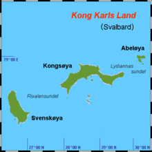
Abel Island (Norwegian: Abeløya) is an island in Svalbard. It is the third-largest island of Kong Karls Land with an area of 13 km (5.0 sq mi). It is named after the Norwegian mathematician Niels Henrik Abel. Abel Island is separated from Kongsøya by the strait Lydiannasundet.
References
- Churchill, Robin R. 2001. Claims to Maritime Zones in the Arctic—Law of the Sea Normality or Polar Peculiarity? In Alex G. Oude Elferink & Donald R. Rothwell (eds.), The Law of the Sea and Polar Maritime Delimitation and Jurisdiction, pp. 105–124. The Hague: Martinus Nijhoff Publishers, p. 120.
- Symmons, Clive R. 2014. Maritime Zones from Islands and Rocks. In S. Jayakumar, Tommy Koh, & Robert Beckman (eds.), The South China Sea Disputes and Law of the Sea, pp. 55–120. Cheltenham, UK: Edward Elgar, p. 101.
- Mills, William James. 2003. Exploring Polar Frontiers: A Historical Encyclopedia. Volume 1: A–L. Santa Barbara, CA: ABC Clio, p. 348.
- "Abeløya (Svalbard)". Norwegian Polar Institute. Archived from the original on 4 December 2014. Retrieved 10 July 2013.
- "Lydiannasundet (Svalbard)". Norwegian Polar Institute. Archived from the original on 4 December 2014. Retrieved 10 July 2013.
This Svalbard location article is a stub. You can help Misplaced Pages by expanding it. |