| Achthoven | |
|---|---|
| Hamlet | |
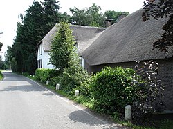
 House De Witte Swaen in Achthoven House De Witte Swaen in Achthoven | |
  | |
| Coordinates: 52°3′33″N 4°59′39″E / 52.05917°N 4.99417°E / 52.05917; 4.99417 | |
| Country | Netherlands |
| Province | Utrecht |
| Municipality | Montfoort |
| Time zone | UTC+1 (CET) |
| • Summer (DST) | UTC+2 (CEST) |
| Postal code | 3417 |
| Dialing code | 0348 |
Achthoven is a hamlet in the Dutch province of Utrecht. It is a part of the municipality of Montfoort, and lies about 6 km northwest of IJsselstein. Between 1818 and 1857, Achthoven was a separate municipality; it merged with Linschoten in 1857.
Achthoven is sometimes divided into two hamlets: Achthoven-West and Achthoven-Oost.
It was first mentioned in 1306 as "van dien achtehoeven", and means "eight parcels of land". Achthoven is not a statistical entity, and the postal authorities have placed it under Montfoort. It has place name sign, however they read Montfoort. In 1840, it was home to 105 people. Nowadays, it consists of about 60 houses.
Gallery
References
- ^ "Postcode 3417 in Montfoort". Postcode bij adres (in Dutch). Retrieved 28 March 2022.
- ^ ANWB Topografische Atlas Nederland, Topografische Dienst and ANWB, 2005.
- Ad van der Meer and Onno Boonstra, Repertorium van Nederlandse gemeenten, KNAW, 2011.
- "Achthoven - (geografische naam)". Etymologiebank (in Dutch). Retrieved 28 March 2022.
- "Kerncijfers wijken en buurten 2021". Central Bureau of Statistics. Retrieved 27 March 2022.
Not found
- "Achthoven (Montfoort)". Plaatsengids (in Dutch). Retrieved 28 March 2022.
| Populated places in the municipality of Montfoort | |
|---|---|
| Towns | |
| Villages | |
| Hamlets | |
| List of cities, towns and villages in Utrecht | |
This Utrecht location article is a stub. You can help Misplaced Pages by expanding it. |

