| Mirna | |
|---|---|
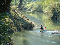
 The Mirna River in Istria, Croatia The Mirna River in Istria, Croatia | |
| Location | |
| Country | Croatia |
| Physical characteristics | |
| Mouth | |
| • location | Adriatic Sea |
| • coordinates | 45°18′59″N 13°35′41″E / 45.3164°N 13.5948°E / 45.3164; 13.5948 |
| Length | 53 km (33 mi) |
| Basin size | 458 km (177 sq mi) |

The Mirna (Italian: Quieto) is a river in Istria, Croatia. In ancient times it was called the Aquilis. It is Istria's longest and richest river, being 53 km (33 mi) long and having a basin covering an area of 458 km (177 sq mi). It rises near Buzet, passes along Motovun and empties into the Adriatic Sea near Novigrad.
References
- ^ Statistical Yearbook of the Republic of Croatia 2017 (PDF) (in Croatian and English). Zagreb: Croatian Bureau of Statistics. December 2017. p. 47. ISSN 1333-3305. Archived from the original (PDF) on 13 November 2018. Retrieved 23 May 2018.
- "Region of Istria: Geographic data". Archived from the original on 2007-06-06. Retrieved 2008-07-30.
Further reading
- Blažević, Marija (1986). "Istarske rijeke" [Istrian Rivers]. Priroda: popularni časopis hrvatskog prirodoslovnog društva. Vol. 72, no. 8. pp. 228–231. ISSN 0351-0662.
External links
| Hydrography of Croatia | ||||||
|---|---|---|---|---|---|---|
| Rivers |
|  | ||||
| Lakes | ||||||
| Valleys, estuaries, canyons, wetlands | ||||||
| Waterfalls | ||||||
| Canals |
| |||||
| Adriatic Sea | ||||||
This Istria County geography article is a stub. You can help Misplaced Pages by expanding it. |
This article related to a river in Croatia is a stub. You can help Misplaced Pages by expanding it. |