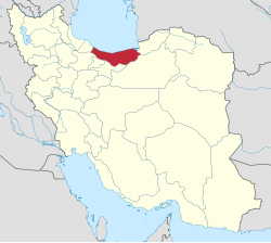
County in Mazandaran, Iran
| Babolsar County Persian: شهرستان بابلسر | |
|---|---|
| County | |
 Location of Babolsar County in Mazandaran province (top center, green) Location of Babolsar County in Mazandaran province (top center, green) | |
 Location of Mazandaran province in Iran Location of Mazandaran province in Iran | |
| Coordinates: 36°40′55″N 52°43′10″E / 36.68194°N 52.71944°E / 36.68194; 52.71944 | |
| Country | Iran |
| Province | Mazandaran |
| Capital | Babolsar |
| Districts | Central, Bahnemir, Rudbast |
| Area | |
| • Total | 345.70 km (133.48 sq mi) |
| Population | |
| • Total | 135,191 |
| • Density | 390/km (1,000/sq mi) |
| Time zone | UTC+3:30 (IRST) |
| Babolsar County can be found at GEOnet Names Server, at this link, by opening the Advanced Search box, entering "9207228" in the "Unique Feature Id" form, and clicking on "Search Database". | |
Babolsar County (Persian: شهرستان بابلسر) is in Mazandaran province, Iran, on the Caspian Sea. Its capital is the city of Babolsar.
History
After the 2006 National Census, Fereydunkenar District was separated from the county in the establishment of Fereydunkenar County.
Demographics
Population
At the time of the 2006 census, the county's population was 172,600 in 46,595 households. The following census in 2011 counted 124,323 people in 37,838 households. The 2016 census measured the population of the county as 135,191 in 44,482 households.
Administrative divisions
Babolsar County's population history and administrative structure over three consecutive censuses are shown in the following table.
| Administrative Divisions | 2006 | 2011 | 2016 |
|---|---|---|---|
| Central District | 67,211 | 72,046 | 80,561 |
| Babolrud RD | 11,644 | 13,178 | 11,244 |
| Saheli RD | 7,695 | 8,391 | 9,351 |
| Babolsar (city) | 47,872 | 50,477 | 59,966 |
| Bahnemir District | 22,090 | 23,284 | 24,001 |
| Azizak RD | 3,860 | 4,224 | 4,283 |
| Bahnemir RD | 11,394 | 11,650 | 11,812 |
| Bahnemir (city) | 6,836 | 7,410 | 7,906 |
| Fereydunkenar District | 56,055 | ||
| Barik Rud RD | 4,506 | ||
| Emamzadeh Abdollah RD | 17,097 | ||
| Fereydunkenar (city) | 34,452 | ||
| Rudbast District | 27,244 | 28,988 | 30,629 |
| Khoshk Rud RD | 5,974 | 6,352 | 5,458 |
| Pazevar RD | 17,727 | 18,539 | 17,282 |
| Hadishahr (city) | 3,543 | 4,097 | 7,889 |
| Total | 172,600 | 124,323 | 135,191 |
| RD = Rural District | |||
See also
[REDACTED] Media related to Babolsar County at Wikimedia Commons
Notes
- Transferred to Fereydunkenar County
- Renamed Barik Rud-e Shomali Rural District
- Renamed Emamzadeh Abdollah-ye Jonubi Rural District
- Formerly Kalleh Bast
References
- OpenStreetMap contributors (20 October 2024). "Babolsar County" (Map). OpenStreetMap (in Persian). Retrieved 20 October 2024.
- Management and Planning Organization of Mazandaran, 2006 Archived 2013-11-16 at the Wayback Machine
- ^ Census of the Islamic Republic of Iran, 1395 (2016): Mazandaran Province. amar.org.ir (Report) (in Persian). The Statistical Center of Iran. Archived from the original (Excel) on 7 October 2021. Retrieved 19 December 2022.
- Habibi, Hassan (c. 2024) . Approval of the organization and chain of citizenship of the elements and units of the divisions of Mazandaran province, centered in Sari city. lamtakam.com (Report) (in Persian). Ministry of the Interior, Defense Political Commission of the Government Council. Subject Letter 3233.1.5.53; Notification 83346/T144K. Archived from the original on 14 January 2024. Retrieved 14 January 2024 – via Lam ta Kam.
- ^ Davodi, Parviz (c. 2024) . Approval letter regarding the reforms of national divisions in Mazandaran province. lamtakam.com (Report) (in Persian). Ministry of the Interior, Political-Defense Commission of the Government Board. Proposal 93023/42/1/4/1; Notification 156155/T38028K. Archived from the original on 16 January 2024. Retrieved 16 January 2024 – via Lam ta Kam.
- ^ Census of the Islamic Republic of Iran, 1385 (2006): Mazandaran Province. amar.org.ir (Report) (in Persian). The Statistical Center of Iran. Archived from the original (Excel) on 20 September 2011. Retrieved 25 September 2022.
- ^ Census of the Islamic Republic of Iran, 1390 (2011): Mazandaran Province. irandataportal.syr.edu (Report) (in Persian). The Statistical Center of Iran. Archived from the original (Excel) on 19 January 2023. Retrieved 19 December 2022 – via Iran Data Portal, Syracuse University.
- Rahimi, Mohammad Reza (c. 2023) . Divisional reforms in Mazandaran province. qavanin.ir (Report) (in Persian). Ministry of the Interior, Defense Political Commission of the Government Board. Proposals 5622/42/1/4, 144980/42/4/1, and 40794/42/1/4. Archived from the original on 22 May 2023. Retrieved 22 May 2023 – via Laws and Regulations Portal of the Islamic Republic of Iran.
| Mazandaran province, Iran | |
|---|---|
| Capital | |
| Counties and cities | |
| Sights |
|
| populated places | |
| Capital | |||||||||||||||||||||||||||||||
|---|---|---|---|---|---|---|---|---|---|---|---|---|---|---|---|---|---|---|---|---|---|---|---|---|---|---|---|---|---|---|---|
| Districts |
| ||||||||||||||||||||||||||||||