| Beerzerveld | |
|---|---|
| Village | |
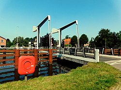
 Neie Scholle Bridge near Beerzerveld Neie Scholle Bridge near Beerzerveld | |
 The village centre (dark green) and the statistical district (light green) of Beerzerveld in the municipality of Ommen. The village centre (dark green) and the statistical district (light green) of Beerzerveld in the municipality of Ommen. | |
  | |
| Coordinates: 52°29′38″N 6°34′36″E / 52.49389°N 6.57667°E / 52.49389; 6.57667 | |
| Country | Netherlands |
| Province | Overijssel |
| Municipality | Ommen |
| Area | |
| • Total | 0.22 km (0.08 sq mi) |
| Elevation | 8 m (26 ft) |
| Population | |
| • Total | 520 |
| • Density | 2,400/km (6,100/sq mi) |
| Time zone | UTC+1 (CET) |
| • Summer (DST) | UTC+2 (CEST) |
| Postal code | 7685 |
| Dialing code | 0523 |
Beerzerveld is a village in the Dutch province of Overijssel. It is a part of the municipality of Ommen, and lies about 16 km north of Almelo.
It was first mentioned in 1860 as Beerzerveld, and means "heath near Beerze". Around 1860, people moved to Beerzerveld to excavate the peat. The hamlet nowadays cooperates with Mariënberg.

References
- ^ "Kerncijfers wijken en buurten 2021". Central Bureau of Statistics. Retrieved 16 March 2022.
- "Postcodetool for 7685PA". Actueel Hoogtebestand Nederland (in Dutch). Het Waterschapshuis. Retrieved 15 March 2022.
- "Beerzerveld". Etymologiebank (in Dutch). Retrieved 16 March 2022.
- "Beerzerveld". Plaatsengids (in Dutch). Retrieved 16 March 2022.
| Populated places in the municipality of Ommen | |
|---|---|
| Towns | |
| Villages | |
| Hamlets | |
| List of cities, towns and villages in Overijssel | |
This Overijssel location article is a stub. You can help Misplaced Pages by expanding it. |