Human settlement in England
| Billington | |
|---|---|
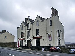
 The Judge Walmesley public house, Billington The Judge Walmesley public house, Billington | |
  | |
| OS grid reference | SD722356 |
| Civil parish | |
| District | |
| Shire county | |
| Region | |
| Country | England |
| Sovereign state | United Kingdom |
| Post town | CLITHEROE |
| Postcode district | BB7 |
| Dialling code | 01254 |
| Police | Lancashire |
| Fire | Lancashire |
| Ambulance | North West |
| UK Parliament | |
| |
Billington is a village in the Ribble Valley district of Lancashire, England. It lies between the villages of Whalley and Langho. It forms part of the Billington and Langho civil parish and contains the schools St Augustine's RC High School, St Leonard's Primary and St Mary's Primary. The village population at the 2011 census was 1,409.
The 16th century Chapel of St Leonard is a Grade I listed building. According to local tradition, the chapel was constructed using materials taken from Whalley Abbey following the dissolution of the monasteries in the Tudor period, but this has never been conclusively proven.
History
In 798, early in his reign, Eardwulf of Northumbria fought a battle at Billington Moor against a nobleman named Wada, who had been one of those who killed Æthelred I of Northumbria. Wada was defeated and driven into exile.
A charter written in 1308 mentions a hermitage by the rocks on the eastern side of Billington.
The village has been known previously as Billindon (1203), Billinton (1208), Bilingdon (1241), Belyngton or Bilyngton (14th–16th centuries).
In the 16th century, tenants of the village shared common land known as Billington Common with tenants of local villages Great Harwood and Wilpshire. There also existed a wood of approximately 60 acres named Elker, which contained oak trees, as well as hazel and alder. Oak and ash trees could also be found in the smaller Nab wood, which was around 40 acres.
See also
References
- UK Census (2011). "Local Area Report – Billington Built-up area (E35000046)". Nomis. Office for National Statistics. Retrieved 27 May 2019.
- ^ Farrer, W. and Brownbill, J. (editors) (1911) "Townships: Billington", A History of the County of Lancaster: Volume 6, pp. 325–334, accessed 2 September 2014.
External links
This Lancashire location article is a stub. You can help Misplaced Pages by expanding it. |