| Bracquemont | |
|---|---|
| Part of Petit-Caux | |
| Location of Bracquemont | |
  | |
| Coordinates: 49°56′29″N 1°08′46″E / 49.9414°N 1.1461°E / 49.9414; 1.1461 | |
| Country | France |
| Region | Normandy |
| Department | Seine-Maritime |
| Arrondissement | Dieppe |
| Canton | Dieppe-2 |
| Commune | Petit-Caux |
| Area | 4.84 km (1.87 sq mi) |
| Population | 857 |
| • Density | 180/km (460/sq mi) |
| Time zone | UTC+01:00 (CET) |
| • Summer (DST) | UTC+02:00 (CEST) |
| Postal code | 76370 |
| Elevation | 0–97 m (0–318 ft) (avg. 85 m or 279 ft) |
| French Land Register data, which excludes lakes, ponds, glaciers > 1 km (0.386 sq mi or 247 acres) and river estuaries. | |
Bracquemont (French pronunciation: [bʁakmɔ̃]) is a former commune in the Seine-Maritime department in the Normandy region in northern France. On 1 January 2016, it was merged into the new commune of Petit-Caux.
Geography
A farming village situated in the Pays de Caux, 1 mile (1.6 km) east of the neighbouring town of Dieppe, at the junction of the D100 and the D113 roads. Huge cliffs, overlooking the English Channel, form the commune's northern border
Heraldry
 |
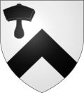
The arms of Bracquemont are blazoned : Argent, a chevron and in canton a mallet sable.
|
Population
| Year | 1962 | 1968 | 1975 | 1982 | 1990 | 1999 | 2006 |
|---|---|---|---|---|---|---|---|
| Population | 495 | 550 | 658 | 786 | 821 | 830 | 926 |
| From the year 1962 on: No double counting—residents of multiple communes (e.g. students and military personnel) are counted only once. | |||||||
Places of interest
- The church of Notre-Dame, dating from the seventeenth century.
- A pre-Roman archaeology site – the “Cité des Limes”.
See also
References
- Téléchargement du fichier d'ensemble des populations légales en 2019, INSEE
- Arrêté préfectoral 26 November 2015 (in French)
This Dieppe geographical article is a stub. You can help Misplaced Pages by expanding it. |