| Bukov Vrh nad Visokim Bukov Vrh (until 1997) | |
|---|---|
 | |
 | |
| Coordinates: 46°6′39.7″N 14°13′33.59″E / 46.111028°N 14.2259972°E / 46.111028; 14.2259972 | |
| Country | |
| Traditional region | Upper Carniola |
| Statistical region | Upper Carniola |
| Municipality | Škofja Loka |
| Area | |
| • Total | 2.74 km (1.06 sq mi) |
| Elevation | 740.6 m (2,429.8 ft) |
| Population | |
| • Total | 42 |
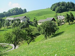
Bukov Vrh nad Visokim (pronounced [ˈbuːkɔu̯ ˈʋəɾx nad ʋiˈsɔːkɔm]) is a settlement above Visoko pri Poljanah in the Municipality of Škofja Loka in the Upper Carniola region of Slovenia.
Geography
Bukov Vrh nad Visokim is a dispersed settlement in the northwestern part of the Polhov Gradec Hills. It consists of the isolated Dolinec, Golar, Kuzovec, Skobelj, and Švint farms, as well as the hamlet of Podskalar (with the Boštar, Brnovi, and Šuštar farms). The highest elevation in the settlement is Pasja ravan (literally, 'dog plateau', elevation 1,020 meters or 3,350 feet). Sovpat Creek, a tributary of the Poljane Sora River, borders the settlement to the northeast and is fed by several small creeks in the settlement. The name Sovpat is the Poljane dialect form of the word sopot 'stream with waterfalls'.
Name
The name Bukov Vrh nad Visokim literally means 'beech peak above Visoko'. Like similar names (e.g., Bukovo, Bukovica, Bukovec, etc.), it is derived from the Slovene adjective bukov, from the common noun bukev 'beech', referring to the local vegetation.
History
The area was settled between the 12th and early 14th centuries by ethnic Slovenians from Carinthia. During the Second World War there was an engagement between German forces and members of the Partisans' Cankar Brigade at the Skobelj farm, where there is a small memorial. In the 1970s, the Yugoslav People's Army reduced the elevation of Pasja ravan by about 10 meters (33 ft) in order to install bunkers and launching sites for S-125 Neva antiaircraft missiles.
Bukov Vrh nad Visokim was established as a separate settlement in 1997, when it was split off from Bukov Vrh.
References
- Statistical Office of the Republic of Slovenia
- ^ Savnik, Roman (1968). Krajevni leksikon Slovenije, vol. 1. Ljubljana: Državna založba Slovenije. p. 354.
- Snoj, Marko (2009). Etimološki slovar slovenskih zemljepisnih imen. Ljubljana: Modrijan. p. 86.
- Jenko, Marjan (January 2006). "Pasja Ravan ni več najvišja!" (PDF). Planinski vestnik (in Slovenian): 72. Retrieved March 11, 2020.
- Škodič, Dušan (August 2014). "Zakaj smo morali včasih zaključiti izlet že pod vrhom hriba?". Planinski vestnik (in Slovenian) (8): 32. Retrieved March 11, 2020.
- Ježovnik, Franc (September 1996). "Pasja ravan" (PDF). Planinski vestnik (in Slovenian) (9): 403. Retrieved March 11, 2020.
- "Naselje Bukov Vrh nad Visokim". Krajevna imena. Statistični urad Republike Slovenije. Retrieved July 31, 2024.
External links
- [REDACTED] Media related to Bukov Vrh nad Visokim at Wikimedia Commons
- Bukov Vrh nad Visokim on Geopedia
This article about the Municipality of Škofja Loka in Slovenia is a stub. You can help Misplaced Pages by expanding it. |
