Town in Victoria, Australia
| Bundalong Victoria | |||||||||||||||
|---|---|---|---|---|---|---|---|---|---|---|---|---|---|---|---|
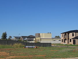
 Houses at Bundalong Houses at Bundalong | |||||||||||||||
 | |||||||||||||||
| Coordinates | 36°02′S 146°10′E / 36.033°S 146.167°E / -36.033; 146.167 | ||||||||||||||
| Population | 428 (2016 census) | ||||||||||||||
| Postcode(s) | 3730 | ||||||||||||||
| Location |
| ||||||||||||||
| LGA(s) | Shire of Moira | ||||||||||||||
| State electorate(s) | Ovens Valley | ||||||||||||||
| Federal division(s) | Nicholls | ||||||||||||||
| |||||||||||||||
Bundalong is a town in Victoria, Australia located on the Murray River and the Murray Valley Highway, east of Yarrawonga. At the 2016 census, Bundalong had a population of 428. Bundalong is in the Shire of Moira local government area, with the name "Bundalong" being an Aboriginal meaning "joined together". The towns farming sites include wheat plantations.
History
The Bundalong Post office opened on 2 October 1876 and closed in 1940.
References
- ^ "2016 Census QuickStats Bundalong". Australian Bureau of Statistics. Retrieved 9 March 2019.
- "The Aboriginal and Other Meanings of many of our Region's Town Names". Retrieved 10 February 2010.
- Nassim Khadem and Melissa Marino (17 May 2005). "Control urged as drought hits meat prices". The Age. Melbourne. Retrieved 25 February 2010.
- Premier Postal History. "Post Office List". Retrieved 11 April 2008.
{{cite web}}: CS1 maint: postscript (link)

| Localities in the Shire of Moira | ||
|---|---|---|
| Town | ||
| Locality |
| |
| ^ - Territory divided with another LGA | ||
This article about a location in Hume (region) is a stub. You can help Misplaced Pages by expanding it. |