| Campodipietra | |
|---|---|
| Comune | |
| Comune di Campodipietra | |
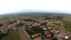
 View of Campodipietra View of Campodipietra | |
 Coat of arms Coat of arms | |
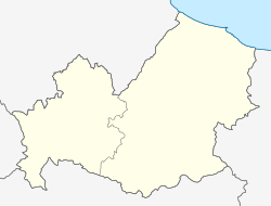
| Location of Campodipietra | |
  | |
| Coordinates: 41°33′N 14°45′E / 41.550°N 14.750°E / 41.550; 14.750 | |
| Country | Italy |
| Region | Molise |
| Province | Campobasso (CB) |
| Government | |
| • Mayor | Giuseppe Notartomaso |
| Area | |
| • Total | 19.72 km (7.61 sq mi) |
| Elevation | 520 m (1,710 ft) |
| Population | |
| • Total | 2,515 |
| • Density | 130/km (330/sq mi) |
| Demonym | Campopetresi |
| Time zone | UTC+1 (CET) |
| • Summer (DST) | UTC+2 (CEST) |
| Postal code | 86010 |
| Dialing code | 0874 |
| Website | Official website |
Campodipietra is a comune (municipality) in the Province of Campobasso in the Italian region Molise, located about 7 kilometres (4 mi) east of Campobasso.
It was built on a rocky spur around the church of San Martino, which rises in the place of the ancient barons' castle, by a colony of German soldiers in the 13th century. The original borough was surrounded by walls, where only three doors opened. There is another smaller church, San Bonaventura, connected to a peculiar story: the inhabitants gathered there in 1705 to vote which should be their patron saint between San Bernardino from Siena and San Martino, and the latter was chosen.
Campodipietra borders the following municipalities: Campobasso, Ferrazzano, Gildone, Jelsi, San Giovanni in Galdo, Toro.
References
- "Superficie di Comuni Province e Regioni italiane al 9 ottobre 2011". Italian National Institute of Statistics. Retrieved 16 March 2019.
- All demographics and other statistics: Italian statistical institute Istat.
- "Popolazione Residente al 1° Gennaio 2018". Italian National Institute of Statistics. Retrieved 16 March 2019.
External links
This article on a location in Molise is a stub. You can help Misplaced Pages by expanding it. |