Town in South Australia
| Thevenard South Australia | |||||||||||||||
|---|---|---|---|---|---|---|---|---|---|---|---|---|---|---|---|
 Memorial at Pinky Point, Thevenard, commemorating people who have lost their lives at sea; ships at the jetty are loading gypsum Memorial at Pinky Point, Thevenard, commemorating people who have lost their lives at sea; ships at the jetty are loading gypsum | |||||||||||||||
 | |||||||||||||||
| Coordinates | 32°08′S 133°39′E / 32.133°S 133.650°E / -32.133; 133.650 | ||||||||||||||
| Population | 563 (SAL 2021) | ||||||||||||||
| Established | 1923 | ||||||||||||||
| Postcode(s) | 5690 | ||||||||||||||
| Time zone | ACST (UTC+9:30) | ||||||||||||||
| • Summer (DST) | ACDT (UTC+10:30) | ||||||||||||||
| Location | 406 km (252 mi) NW of Port Lincoln | ||||||||||||||
| LGA(s) | District Council of Ceduna | ||||||||||||||
| State electorate(s) | Flinders | ||||||||||||||
| Federal division(s) | Grey | ||||||||||||||
| |||||||||||||||
| Footnotes | Adjoining localities | ||||||||||||||
Thevenard (postcode 5690) is a port town in the far west of Eyre Peninsula, South Australia. It is contiguous with the larger town of Ceduna. Its name derives from nearby Cape Thevenard, which in turn was named after Antoine-Jean-Marie Thévenard, a French admiral. In the 2021 census, Thevenard had a population of 563.

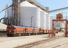
The port handles bulk grain, gypsum, salt and zircon. Thevenard is a terminus of the privately operated Lake MacDonnell–Thevenard railway, which delivers three trains of bulk gypsum daily from the Lake MacDonnell mine, 65 kilometres (40 miles) to the west. Production from the mine, owned by Gypsum Resources Australia, is about 3.5 million tonnes (3.4 million long tons) per year.
Iluka Resources exports about 300,000 tonnes (295,000 long tons) of zircon concentrate from Thevenard per year, which the company mines and processes at the Jacinth Ambrosia Mine, 270 kilometres (170 miles) north-west of Thevenard; delivery is by road.
The jetty has two berths, each capable of handling ships of 198 metres (650 feet) length over all and 28 m (92 ft) beam, with a berthing pocket 30 m (98 ft) wide and 9.8 m (32 ft) deep. A gantry supports a load-out conveyor and a discharge boom with a travel length of 160 m (520 ft) capable of bulk loading grain at 750 tonnes (740 long tons) per hour and gypsum at 950 tonnes (930 long tons) per hour into ships' holds with a maximum outreach of 18 metres (59 feet).
Thevenard is in the District Council of Ceduna local government area, the South Australian House of Assembly electoral district of Flinders and the Australian House of Representatives Division of Grey.
Greek immigration to Thevenard, especially by people in the fishing industry, has been important in shaping the town's culture. Greeks from Thevenard are believed to have introduced eating barramundi to Anglo-Celtic Australians.
External links
References
- Australian Bureau of Statistics (28 June 2022). "Thevenard (suburb and locality)". Australian Census 2021 QuickStats. Retrieved 28 June 2022.

- ^ "Search result for "Thevenard (LOCB)" (Record no SA0066056) with the following layers selected – "Suburbs and Localities" and " Place names (gazetteer)"". Property Location Browser. Government of South Australia. Retrieved 23 July 2016.
- ^ "District of Flinders Background Profile". Electoral Commission SA. Retrieved 9 September 2015.
- ^ "Federal electoral division of Grey" (PDF). Australian Electoral Commission. Retrieved 24 July 2015.
- Australian Bureau of Statistics (28 June 2022). "Thevenard (Suburbs and Localities)". 2021 Census QuickStats. Retrieved 23 January 2023.

- "Lake Macdonnell". MiningLink. Retrieved 12 August 2015.
- ^ Regional Development Australia – Whyalla & Eyre Peninsula "Port of Thevenard | Major Projects | Eyre Peninsula | SA" Retrieved 2013-11-24
- "Greek currents in Australian waters". 14 August 2017.
| Towns and localities of the District Council of Ceduna | |
|---|---|
| Eyre Peninsula, South Australia | |||||||
|---|---|---|---|---|---|---|---|
| Cities | |||||||
| Townships | |||||||
| Governance |
| ||||||
| Protected areas | |||||||
| Coastal features |
| ||||||
| Islands adjoining Eyre Peninsula coast |
| ||||||
| Infrastructure |
| ||||||
| Related and uncategorised | |||||||
| Australian places named by French explorers in the 18th and 19th centuries | ||
|---|---|---|
| South Australia |
|  |
| Western Australia | ||
| Only places with the name still in use in either the original or anglicised version are listed above. Many names have been anglicised; for these the original French name appears in brackets. | ||
This South Australia geography article is a stub. You can help Misplaced Pages by expanding it. |