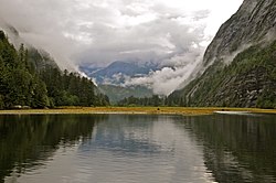
Mussel Inlet is in inlet in the North Coast region of the Canadian province of British Columbia. It is a northeast extension of Sheep Passage, and part of the Fiordland Conservancy.
Name origin and history
It was first charted in 1793 by James Johnstone, one of George Vancouver's officers during his 1791-95 expedition. It was here the men ate mussels that poisoned and killed one of them, John Carter, for whom Carter Bay is named; it is at the junction of Finlayson Channel and the west end of Sheep Passage at 52°49′33″N 128°23′46″W / 52.82583°N 128.39611°W / 52.82583; -128.39611 (Carter Bay). Poison Cove at 52°54′21″N 128°02′00″W / 52.90583°N 128.03333°W / 52.90583; -128.03333 (Poison Cove) being the location where the mussels were harvested. A creek northwest into that cove is Poison Cove Creek.
References
- "Mussel Inlet". BC Geographical Names.
- BC Names/GeoBC entry "Carter Bay"
- BC Names/GeoBC entry "Poison Cove"
- BC Names/GeoBC entry "Poison Cove"
- BC Names/GeoBC entry "Poison Cove Creek"
- Vancouver, George, and John Vancouver (1801). A voyage of discovery to the North Pacific ocean, and round the world. London: J. Stockdale.
{{cite book}}: CS1 maint: multiple names: authors list (link)
52°54′N 128°07′W / 52.900°N 128.117°W / 52.900; -128.117
This article about a location on the North Coast of British Columbia, Canada is a stub. You can help Misplaced Pages by expanding it. |