52°12′43″N 0°06′54″E / 52.212°N 0.115°E / 52.212; 0.115


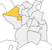
Castle is a district and electoral ward of the city of Cambridge, England. It is named after the former Cambridge Castle which once stood on Castle Mound. In the UK Census 2011 the population of Castle was 9,785.
The population of Castle Ward is being increased by the North West Cambridge Development, at its centre, Eddington, which began to be occupied in 2017.
Castle ward borders the following other wards within the city of Cambridge (from North, proceeding clockwise): Arbury, Market and Newnham. Castle is represented by three councillors on Cambridge City Council. Castle Electoral Division, which has different boundaries since 2017, is represented by one councillor on Cambridgeshire County Council.
References
- ^ "Cambridge City Ward Map". Cambridge City Council. Retrieved 12 October 2016.
- "Area: Castle (Ward), Key Figures for 2011 Census". Neighbourhood Statistics. Office for National Statistics. Retrieved 12 October 2016.
- "First residents move into Eddington". North West Cambridge Development. 7 July 2017. Archived from the original on 10 September 2017. Retrieved 10 January 2017.
- "Find your Councillor". Cambridge City Council. Archived from the original on 22 August 2016. Retrieved 12 October 2016.
- "Councillors". Cambridgeshire County Council. Retrieved 12 October 2016.
See also
| Electoral wards of Cambridge City Council | |
|---|---|
| Current wards | |
This Cambridgeshire location article is a stub. You can help Misplaced Pages by expanding it. |