 | |
| Location | Castleton |
|---|---|
| Region | Derbyshire, England |
| Coordinates | 53°20′36″N 1°46′37″W / 53.34333°N 1.77694°W / 53.34333; -1.77694 |
| History | |
| Periods | late Middle Ages |
| Scheduled monument | |
| Official name | Town defences 270m north and 350m north east of Peveril Castle |
| Designated | 15 February 1999 |
| Reference no. | 1018868 |
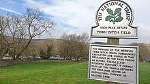
The Castleton town defences in Castleton, Derbyshire, consist of a ditch and bank constructed during the 1190s. The ditch was part of Peveril Castle's medieval defence system.
The town defences were classified as a scheduled monument on 15 February 1999.
See also
References
- Historic England. "Town defences 270m north and 350m north east of Peveril Castle (1018868)". National Heritage List for England. Retrieved 16 May 2023.
- "Castleton Town Defences (The Gatehouse Record)". www.gatehouse-gazetteer.info. Retrieved 16 May 2023.
- "Castleton town defences | Castellogy". Retrieved 16 May 2023.
- Appleton, Mike (15 May 2018). 50 Gems of Derbyshire: The History & Heritage of the Most Iconic Places. Amberley Publishing Limited. ISBN 978-1-4456-6727-0.
- "Town defences 270m north and 350m north east of Peveril Castle, Castleton - 1018868 | Historic England". historicengland.org.uk. Retrieved 16 May 2023.