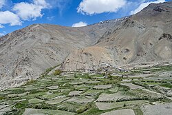
Village in Ladakh, India
| Chah Cha | |
|---|---|
| village | |
 Chah village, June 2024 Chah village, June 2024 | |
 | |
| Coordinates: 33°14′38.25″N 77°07′33.92″E / 33.2439583°N 77.1260889°E / 33.2439583; 77.1260889 | |
| Country | |
| State | Ladakh |
| Area | |
| • Total | 0.838 km (0.324 sq mi) |
| Elevation | 3,920 m (12,860 ft) |
| Population | |
| • Total | 465 |
| • Density | 550/km (1,400/sq mi) |
| Languages | |
| Time zone | UTC+5:30 (IST) |
| Postal Index Number | 194302 |
| Website | https://kargil.nic.in/ |
Chah (also Cha) is a small village in the Lungnak valley in Zanskar tehsil, Kargil district, Ladakh, India. The village is situated at the base of a mountain range on the right bank of the Tsarap River. It is located on the Padum-Darcha road, 47 km (29 mi) south from Padum.
Description
Chah (elevation 3,920 m (12,860 ft)) is a small village in the Lungnak valley on the right bank of the Tsarap River. It is located at a distance of 47 km (29 mi) from Padum on the Padum-Darcha road. The distance from Darcha in Lahaul is 82 km (51 mi), the road climbing over the 5,091 m (16,703 ft) Shinko La pass. Chah village has an area of 83.80 hectares (207.1 acres).
Demographics
The population as of the 2011 Census was 465 with 61 households. Females comprised 40.2% of the population. The literacy rate was 56%. All but 2 of the 465 persons belonged to scheduled tribes.
Governance
The Cha Gram Panchayat is a government office and local self-government body. The villages of Chah and Shunshday (Shan Shaday) come under its jurisdiction. In 2011, the population of these two villages was 709.
Amenities
Chah has a pre-primary and primary school. Household power supply and mobile phone coverage are available. The village has a primary health sub-centre (PHS). There is an India Post branch post office with PIN code 194302.
Economy
The economy is largely agrarian with tourism also providing jobs and income. As the annual precipitation is low, fields are irrigated through channels from streams fed by snow-melt. About 46% of the agricultural land is irrigated.
Tourism

From Chah there is a 6 km (3.7 mi) trail to Phugtal Monastery. The trail is difficult in some places. The distance can be covered in 2-3 hours.
Transport
In June 2024, the Himachal Road Transport Corporation (HRTC) announced that it would soon commence a bus service from Keylong in Lahaul to Padum. This would run on the Nimmu-Padum-Darcha road and would serve Chah. Taxis are available.
See also
References
- "Padum - Cha route". OpenStreetMap. 24 July 2024. Retrieved 24 July 2024.
- ^ District Census Handbook: Kargil, Jammu & Kashmir -- Village and Town Wise Primary Census Abstract (PCA). 3 Part XII B. Directorate of Census Operations, Himachal Pradesh, Ministry of Home Affairs, Govt of India. 2011.
- "Local Government Directory: LGD - Panchayat - Kargil - Jul24.xls". Ministry of Panchayati Raj. Retrieved 30 August 2024.
- ^ District Census Handbook: Kargil, Jammu & Kashmir -- Village and Town Directory. 2 Part XII A. Directorate of Census Operations, Himachal Pradesh, Ministry of Home Affairs, Govt of India. 2011.
- "Find pincode: Ladakh - Kargil". India Post, Dept. of Posts, Ministry of Communications, Govt of India. Retrieved 24 July 2024.
- "Kargil - Ladakh: The climate and soil condition of the district". LAHDCK – Ladakh Autonomous Hill Development Council, Kargil. 13 July 2024. Retrieved 24 July 2024.
- "Chah - Phuktal route". OpenStreetMap. 24 July 2024. Retrieved 24 July 2024.
- Khan, V. (6 August 2023). "Phugtal Monastery – A Complete Travel Guide: Day 2 – Cha to Phugtal Monastery to Purne". Vargis Khan. Retrieved 24 July 2024.
- Tribune News Service (22 June 2024). "Keylong-Padum trial run a success, service on anvil". The Tribune (India). Retrieved 21 July 2024.