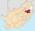
Place in Mpumalanga, South Africa
| Charl Cilliers | |
|---|---|
  | |
| Coordinates: 26°40′S 29°11′E / 26.667°S 29.183°E / -26.667; 29.183 | |
| Country | South Africa |
| Province | Mpumalanga |
| District | Gert Sibande |
| Municipality | Govan Mbeki |
| Area | |
| • Total | 1.54 km (0.59 sq mi) |
| Population | |
| • Total | 768 |
| • Density | 500/km (1,300/sq mi) |
| Racial makeup (2011) | |
| • Black African | 86.6% |
| • Coloured | 0.4% |
| • Indian/Asian | 0.4% |
| • White | 12.6% |
| First languages (2011) | |
| • Zulu | 63.0% |
| • Afrikaans | 10.8% |
| • S. Ndebele | 6.5% |
| • Sotho | 5.7% |
| • Other | 14.0% |
| Time zone | UTC+2 (SAST) |
| PO box | 2301 |
| Area code | 017 |
Charl Cilliers is a settlement in Gert Sibande District Municipality in the Mpumalanga province of South Africa. The village is some 32 km north of Standerton.
History
Originally known as Van Tondershoek, it was renamed in 1917 after the Voortrekker Sarel Cilliers.
References
- ^ "Main Place Charl Cilliers". Census 2011.
- Raper, Peter E. "Dictionary of Southern African Place Names". HRSC. p. 113.
| Municipalities and communities of Gert Sibande District Municipality, Mpumalanga | ||
|---|---|---|
| District seat: Ermelo | ||
| Govan Mbeki |  | |
| Albert Luthuli | ||
| Mkhondo | ||
| Msukaligwa | ||
| Lekwa | ||
| Pixley ka Seme | ||
| Dipaleseng | ||
This Mpumalanga location article is a stub. You can help Misplaced Pages by expanding it. |