Village in Uttar Pradesh, India
| Chitarkoni Saleempur | |
|---|---|
| Village | |
| Saraila Chitarkoni | |
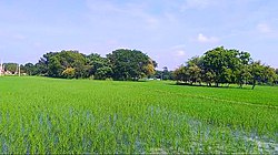
 A Image of a farm in Chitarkoni A Image of a farm in Chitarkoni | |
 | |
| Coordinates: 25°22′04″N 83°40′35″E / 25.3678449°N 83.6763355°E / 25.3678449; 83.6763355 | |
| Country | |
| State | Uttar Pradesh |
| District | Ghazipur |
| Established | 1640; 385 years ago (1640) |
| Founded by | Zamindar Saleem khan |
| Government | |
| • Body | Gram panchayat |
| Area | |
| • Total | 701.46 ha (1,733.35 acres) |
| • Land | 692.684 ha (1,711.659 acres) |
| • Water | 8.776 ha (21.686 acres) |
| Population | |
| • Total | 2,377 |
| • Density | 340/km (880/sq mi) |
| Languages | |
| • Official | Hindi |
| Time zone | UTC+5:30 (IST) |
| Vehicle registration | UP |
| Website | up |
Chitarkoni is a village in Kamsaar in the Indian state of Uttar Pradesh.
History

Chitarkoni was founded by Zamindar Saleem Khan in middle 1640s., a great-grandson of Raja Narhar Khan, founder of Kamsar. When zamindar Saleem Khan , his descendants build a mosque in Chitarkoni name as Chitarkoni Jama Masjid. The Jama Masjid of Chitarkoni was renovated in 1960s by the villagers. There are many Muhallahs in the village but the main are said As. Purabh Muhalla, and Pachim Muahallah. As of 2011 census, main population of the village lived in an area of 37.5 acres and had 644 house holds.
| Year | Pop. | ±% |
|---|---|---|
| 1861 | 802 | — |
| 1871 | 885 | +10.3% |
| 1881 | 972 | +9.8% |
| 1891 | 1,069 | +10.0% |
| 1901 | 1,176 | +10.0% |
| 1911 | 1,293 | +9.9% |
| 1921 | 1,422 | +10.0% |
| 1931 | 1,565 | +10.1% |
| 1941 | 1,722 | +10.0% |
| 1951 | 1,808 | +5.0% |
| 1961 | 1,800 | −0.4% |
| 1971 | 1,980 | +10.0% |
| 1981 | 2,178 | +10.0% |
| 1991 | 2,395 | +10.0% |
| 2001 | 2,200 | −8.1% |
| 2011 | 2,377 | +8.0% |
| Source:Census of India | ||
References
- "Bhulekh". Archived from the original on 30 December 2020.
- "Madina masjid in Chitarkoni".
- "Bhulekh". Archived from the original on 30 December 2020.
- "Evolution and Spatial Organization of Clan settlements in Middle Ganga valley".
- "Census of India". mospi.gov.in. Archived from the original on 13 August 2008. Retrieved 23 June 2008.
- "2011 census of India". Archived from the original on 14 May 2007. Retrieved 28 March 2021.
- "Historical Census of India". Archived from the original on 17 February 2013. Retrieved 5 November 2015.
| Cities and towns in Dildarnagar Kamsar | |
|---|---|
| Dildarnagar Kamsar | |
| People from Kamsar | |
| Other near towns and cities | |
This Ghazipur district location article is a stub. You can help Misplaced Pages by expanding it. |