Census-designated place in Pennsylvania, United States
| Churchtown, Pennsylvania | |
|---|---|
| Census-designated place | |
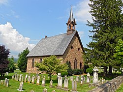
 Bangor Episcopal Church Bangor Episcopal Church | |
  | |
| Coordinates: 40°7′59″N 75°57′53″W / 40.13306°N 75.96472°W / 40.13306; -75.96472 | |
| Country | United States |
| State | Pennsylvania |
| County | Lancaster |
| Township | Caernarvon |
| Area | |
| • Total | 1.90 sq mi (4.92 km) |
| • Land | 1.89 sq mi (4.88 km) |
| • Water | 0.01 sq mi (0.04 km) |
| Elevation | 564 ft (172 m) |
| Population | |
| • Total | 417 |
| • Density | 221.22/sq mi (85.43/km) |
| Time zone | UTC-5 (Eastern (EST)) |
| • Summer (DST) | UTC-4 (EDT) |
| ZIP code | 17555 |
| Area code | 717 |
| FIPS code | 42-13632 |
| GNIS feature ID | 1171873 |
Churchtown is an unincorporated community and census-designated place (CDP) in Caernarvon Township, Lancaster County, Pennsylvania, United States, along Pennsylvania Route 23. The population was 470 as of the 2010 census.
History
The first settlers of the oldest Amish settlement still in existence, the Lancaster Amish settlement, settled near Churchtown.
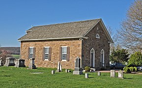
The Bangor Episcopal Church, Caernarvon Presbyterian Church and Edward Davies House are listed on the National Register of Historic Places.
Geography
Churchtown is in eastern Lancaster County, in the center of Caernarvon Township. Pennsylvania Route 23 is the community's Main Street, leading east 4 miles (6 km) to Morgantown and west 20 miles (32 km) to Lancaster, the county seat.
According to the U.S. Census Bureau, the Churchtown CDP has a total area of 1.9 square miles (4.9 km), of which 0.02 square miles (0.04 km), or 0.71%, are water. The community sits on a ridge draining south to the Conestoga River, a west-flowing tributary of the Susquehanna River.
Demographics
| Census | Pop. | Note | %± |
|---|---|---|---|
| 2020 | 417 | — | |
| U.S. Decennial Census | |||
References
- "ArcGIS REST Services Directory". United States Census Bureau. Retrieved October 12, 2022.
- ^ "Census Population API". United States Census Bureau. Retrieved October 12, 2022.
- U.S. Geological Survey Geographic Names Information System: Churchtown, Pennsylvania
- "Total Population: 2010 Census DEC Summary File 1 (P1), Churchtown CDP, Pennsylvania". data.census.gov. U.S. Census Bureau. Retrieved September 18, 2020.
- "6 Takeaways from Our Conversation with Don Kraybill" at lancasteronline.com.
- "National Register Information System". National Register of Historic Places. National Park Service. March 13, 2009.
- "2019 U.S. Gazetteer Files: Places: Pennsylvania". United States Census Bureau. Retrieved September 18, 2020.
- "Census of Population and Housing". Census.gov. Retrieved June 4, 2016.


