Commune in Hauts-de-France, France
| Clerques Klarke | |
|---|---|
| Commune | |
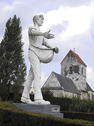
 The Sower and Saint-Barthélémy's church The Sower and Saint-Barthélémy's church | |
 Coat of arms Coat of arms | |
| Location of Clerques | |
  | |
| Coordinates: 50°47′37″N 1°59′43″E / 50.7936°N 1.9953°E / 50.7936; 1.9953 | |
| Country | France |
| Region | Hauts-de-France |
| Department | Pas-de-Calais |
| Arrondissement | Saint-Omer |
| Canton | Lumbres |
| Intercommunality | Pays de Lumbres |
| Government | |
| • Mayor (2020–2026) | Aurélien Dommanget |
| Area | 6.39 km (2.47 sq mi) |
| Population | 314 |
| • Density | 49/km (130/sq mi) |
| Time zone | UTC+01:00 (CET) |
| • Summer (DST) | UTC+02:00 (CEST) |
| INSEE/Postal code | 62228 /62890 |
| Elevation | 37–173 m (121–568 ft) (avg. 47 m or 154 ft) |
| French Land Register data, which excludes lakes, ponds, glaciers > 1 km (0.386 sq mi or 247 acres) and river estuaries. | |
Clerques (French pronunciation: [klɛʁk]; West Flemish: Klarke) is a commune in the Pas-de-Calais department in the Hauts-de-France region of France 10 miles (16 km) northwest of Saint-Omer, in the valley of the river Hem at the foot of the Boulonnais, which is a wooded ridge there. Two hamlets, Audenfort to the west and Le Hamel to the east, make up the remainder of the commune.
Population
| Year | Pop. | ±% p.a. |
|---|---|---|
| 1968 | 186 | — |
| 1975 | 180 | −0.47% |
| 1982 | 209 | +2.16% |
| 1990 | 215 | +0.35% |
| 1999 | 213 | −0.10% |
| 2007 | 249 | +1.97% |
| 2012 | 285 | +2.74% |
| 2017 | 327 | +2.79% |
| Source: INSEE | ||
History
On 13 August 2006 the stone bridge in the village centre, built in 1862, was destroyed after exceptional rainfall upstream at Licques.
Transport
The Chemin de fer de Boulogne à Bonningues (CF de BB) opened a station at Audenfort, near Clerques, on 22 April 1900. Passenger services were withdrawn on 31 December 1935. They were reinstated in November 1942. The CF de BB closed in 1948.
See also
References
- "Répertoire national des élus: les maires" (in French). data.gouv.fr, Plateforme ouverte des données publiques françaises. 13 September 2022.
- "Populations de référence 2022" (in French). The National Institute of Statistics and Economic Studies. 19 December 2024.
- INSEE commune file
- Population en historique depuis 1968, INSEE
- Conseil Général du Pas de Calais - CG62 Archived 2006-11-27 at the Wayback Machine
- Farebrother & Farebrother 2008, p. 139.
- Farebrother & Farebrother 2008, p. 239.
- Farebrother & Farebrother 2008, p. 248.
- Farebrother & Farebrother 2008, p. 276.
Sources
- Farebrother, Martin J B; Farebrother, Joan S (2008). Tortillards of Artois. Usk: The Oakwood Press. ISBN 978-0-85361-554-5.
External links
- Statistical data, INSEE
This Pas-de-Calais geographical article is a stub. You can help Misplaced Pages by expanding it. |