Census-designated place in Virginia, United States
| Clover, Virginia | |
|---|---|
| Census-designated place | |
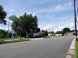
 Center of Clover in 2013 Center of Clover in 2013 | |
  | |
| Coordinates: 36°49′58″N 78°44′00″W / 36.83278°N 78.73333°W / 36.83278; -78.73333 | |
| Country | United States |
| State | Virginia |
| County | Halifax |
| Area | |
| • Total | 7.02 sq mi (18.18 km) |
| • Land | 7.01 sq mi (18.16 km) |
| • Water | 0.008 sq mi (0.02 km) |
| Elevation | 502 ft (153 m) |
| Population | |
| • Total | 438 |
| • Density | 62/sq mi (24.1/km) |
| Time zone | UTC−5 (Eastern (EST)) |
| • Summer (DST) | UTC−4 (EDT) |
| ZIP code | 24534 |
| Area code | 434 |
| FIPS code | 51-17632 |
| GNIS feature ID | 1464998 |
Clover is an unincorporated community and census-designated place (CDP) in rural Halifax County, Virginia, United States. The population as of the 2010 census was 438. Clover was an incorporated town from 1895 until 1998, when it reverted to unincorporated status. Clover was the site of a Rosenwald school, built around 1921 or 1922, with a three-teacher facility on a 2-acre campus.
Black Walnut, a historic plantation house and farm located near Clover, was listed on the National Register of Historic Places in 1991.
Geography
Clover is in northeastern Halifax County, north of U.S. Route 360. It is 14 miles (23 km) northeast of South Boston and 24 miles (39 km) southwest of Keysville via US 360.
According to the U.S. Census Bureau, the Clover CDP has a total area of 7.0 square miles (18.2 km), of which 0.01 square miles (0.02 km), or 0.11%, is water. It is drained by tributaries of the Roanoke River.
Notable people
- J. Steven Griles (b. 1947), former United States Deputy Secretary of the Interior (2001–04) in the George W. Bush administration, coal lobbyist, implicated in the Jack Abramoff scandal
- Henrietta Lacks (1920–1951), source of the HeLa cell line, subject of The Immortal Life of Henrietta Lacks (2010) and The Immortal Life of Henrietta Lacks (film) (2017)
- Willie Lanier (b. 1945), Pro Football Hall of Fame linebacker for Kansas City Chiefs
- Luther Hilton Foster (1888-1949), President of Virginia Normal and Industrial School, now Virginia State University, near Petersburg
- Henry E. Garrett (1894-1973), prominent psychologist at Columbia and UVa, and supporter of racial segregation
References
- ^ "Geographic Identifiers: 2010 Census Summary File 1 (G001): Clover CDP, Virginia". American Factfinder. U.S. Census Bureau. Archived from the original on February 13, 2020. Retrieved March 21, 2018.
- "Rosenwald Schools of Virginia". Virginia#USA Center for Digital History. Archived from the original on March 6, 2016. Retrieved February 27, 2016.
- National Register of Historic Places Multiple-Property Documentation Form, Rosenwald Schools, Virginia Department of Historic Resources, page 67 (pdf page 142). Retrieved December 19, 2021.
- "National Register Information System". National Register of Historic Places. National Park Service. July 9, 2010.
- "Prison Time Is Urged for Griles", The Washington Post, June 16, 2007
- Smith, Van (April 17, 2002). "The Life, Death, and Life After Death of Henrietta Lacks, Unwitting Heroine of Modern Medical Science". Baltimore City Paper. Archived from the original on August 14, 2004. Retrieved January 18, 2010.
- Personal: Luther Hilton Foster, The Journal of Negro History: Vol 34, No 4, October 1949, page 489. Verified December 19, 2021.
- "Clover". Geographic Names Information System. United States Geological Survey, United States Department of the Interior. Retrieved February 9, 2006.
| Municipalities and communities of Halifax County, Virginia, United States | ||
|---|---|---|
| County seat: Halifax | ||
| Towns |  | |
| CDPs | ||
| Unincorporated communities | ||
| Footnotes | ‡This populated place also has portions in an adjacent county or counties | |