| Fier County Qarku i Fierit (Albanian) | |
|---|---|
| County | |
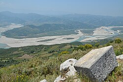
 Vjosa Valley Vjosa Valley | |
| [REDACTED] Emblem | |
 Map of Albania with Fier County highlighted Map of Albania with Fier County highlighted | |
| Coordinates: 40°45′N 19°35′E / 40.750°N 19.583°E / 40.750; 19.583 | |
| Country | |
| Seat | Fier |
| Subdivisions | 6 municipalities: |
| Government | |
| • Council chairman | Evis Sema (PS) |
| Area | |
| • Total | 1,890 km (730 sq mi) |
| • Rank | 8th |
| Population | |
| • Total | 240,377 |
| • Rank | 2nd |
| • Density | 130/km (330/sq mi) |
| Time zone | UTC+1 (CET) |
| • Summer (DST) | UTC+2 (CEST) |
| HDI (2022) | 0.762 high · 10th |
| NUTS Code | AL032 |
| Website | Official Website |
Fier County (Albanian pronunciation: [fieɽ]; Albanian: Qarku Fier), officially the County of Fier (Albanian: Qarku i Fierit), is a county in the Southern Region of the Republic of Albania. It is the eighth largest by area and the third most populous of the twelve counties, with about 240,000 people within an area of 1,890 km (730 sq mi). The county borders on the Adriatic Sea to the west, the counties of Tirana to the north, Elbasan to the northeast, Berat to the east, Gjirokastër to the southeast and Vlorë to the south. It is divided into six municipalities, Fier, Divjakë, Lushnjë, Mallakastër, Patos and Roskovec, all of whom incorporate 42 administrative units.
Geography
Until 2000, Fier County was subdivided into three districts: Fier, Lushnjë, and Mallakastër. Before 2015, it consisted of 42 municipalities.
Economy
Fier County maintains a relatively strong economy within Albania with agriculture and heavy industry serving as a backbone of the area during the communist era. Wages in the county are above the Albanian average. More recently, a service-based economy has become more prominent locally as well as small-scale manufacturing by foreign companies.
Fier additionally has been the home of power-generation in Albania with the construction of the Fier Power Plant during the communist era. Although it was decommissioned in 2007, a joint Greek-Albanian venture was announced in 2023 to revitalize these thermal plants to diversify Albania’s electrical industry.
Demography
| Year | Pop. | ±% |
|---|---|---|
| 1950 | 129,785 | — |
| 1960 | 177,598 | +36.8% |
| 1969 | 242,394 | +36.5% |
| 1979 | 304,476 | +25.6% |
| 1989 | 379,342 | +24.6% |
| 2001 | 382,544 | +0.8% |
| 2011 | 310,331 | −18.9% |
| 2023 | 240,377 | −22.5% |
| Source: | ||
According to the last national census from 2023, Fier County had 240,377 inhabitants. Ethnic groups in the county as of 2011 include:
- Albanians = 241,163 (77.71%)
- Greeks = 332 (0.11%)
- Macedonians = 18 (0.01%)
- Montenegrins = 5 (0.00%)
- Aromanians = 1,553 (0.50%)
- Romani = 1,640 (0,53%)
- Egyptians = 75 (0,02%)
- others = 171 (0.06%)
- no answer = 65,374 (21.07%)
Islam is the largest religion in the county, forming 48.52% of the total population (150,559 people). There are also some Bektashi Muslims with 1.01% (3,137 people), 7.15% percent consisting of believers without a denomination (22,186 people) and Christians forming 15.91% of the county's population (Orthodox (13.76%) (42,993 people), Evangelists (0.11% (331 people) (and Roman Catholics) (1.98%) (6,149 people).
See also
References
- "Konstituohet Këshilli i Qarkut Fier! Evis Sema rizgjidhet për një mandat të dytë si kryetare".
- "Main Results of the Population and Housing Census 2023" (PDF). INSTAT.
- ^ "Law nr. 115/2014" (PDF) (in Albanian). p. 6370. Retrieved 25 February 2022.
- "Division of Albania".
- "Census of Population and Housing". Institute of Statistics Albania.
- "2011 census results" (PDF). Archived from the original (PDF) on 2016-03-04. Retrieved 2015-05-25.
| Counties of Albania | |
|---|---|
| |
| Subdivisions of Fier County | ||
|---|---|---|
| County seat: Fier | ||
| Municipality of Divjakë |  | |
| Municipality of Fier | ||
| Municipality of Lushnjë | ||
| Municipality of Mallakastër | ||
| Municipality of Patos | ||
| Municipality of Roskovec | ||