| Długołęka | |
|---|---|
| Village | |
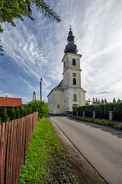
 Church of Saint Michael Archangel Church of Saint Michael Archangel | |
 | |
| Coordinates: 51°10′29″N 17°11′43″E / 51.17472°N 17.19528°E / 51.17472; 17.19528 | |
| Country | |
| Voivodeship | Lower Silesian |
| County | Wrocław |
| Gmina | Długołęka |
| First mentioned | 13th century |
| Population | |
| • Total | 2,620 |
| Time zone | UTC+1 (CET) |
| • Summer (DST) | UTC+2 (CEST) |
| Vehicle registration | DWR |
Długołęka (Polish: [dwuɡɔˈwɛŋka]) (German: Langewiese) is a village in Wrocław County, Lower Silesian Voivodeship, in south-western Poland. It is the seat of the administrative district (gmina) called Gmina Długołęka.
It lies approximately 13 kilometres (8 mi) north-east of the regional capital Wrocław.
History
The first references to the village date back to the 13th century, when it was part of fragmented Piast-ruled Poland. Later on, it also passed to Bohemia (Czechia), Prussia and Germany. A labour camp of the Reich Labour Service was operated in the village under Nazi Germany. It became again part of Poland following Germany's defeat in World War II in 1945.
Transport
The village has a train station with regular connections to Wrocław, Jelcz-Laskowice and Oleśnica
References
- "Central Statistical Office (GUS) - TERYT (National Register of Territorial Land Apportionment Journal)" (in Polish). 2008-06-01.
- "XI Mittelschlesien" (in German). Retrieved 5 November 2022.
This Wrocław County location article is a stub. You can help Misplaced Pages by expanding it. |