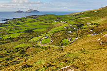
| Native name: Duínis | |
|---|---|
 Deenish Island's north shore from a yacht Deenish Island's north shore from a yacht | |
 | |
| Geography | |
| Location | Atlantic Ocean |
| Coordinates | 51°44′13″N 10°13′13″W / 51.7370°N 10.2203°W / 51.7370; -10.2203 |
| Area | 0.49 km (0.19 sq mi) |
| Highest elevation | 144 m (472 ft) |
| Administration | |
| Ireland | |
| Province | Munster |
| County | Kerry |
| Demographics | |
| Population | 0 (2011) |
| Pop. density | 0/km (0/sq mi) |
Deenish Island (Irish: Duínis) is an island of the Atlantic Ocean belonging to County Kerry, Ireland.
Geography

The island is 122 acres; its highest hill is at 144 m. It's located in the Atlantic Ocean at around 1 km from Scariff Island and 6.1 km from Hogs Head, on the mainland.
History
In 1837 on Deenish (which at that time was called Dinish) resided three families who mainly lived on the cattle which grazed on the island. 1911 census still reported six people living on the island.
|
|
| ||||||||||||||||||||||||||||||||||||||||||||||||||||||||||||||||||||||||||||||
| Source: Central Statistics Office. "CNA17: Population by Off Shore Island, Sex and Year". CSO.ie. Retrieved 12 October 2016. | ||||||||||||||||||||||||||||||||||||||||||||||||||||||||||||||||||||||||||||||||
See also
References
- ^ "Duínis". St. Cronan's School. Retrieved 19 May 2015.
- "Dunkerron Mountains Area - Deenish Island Hill". MountainViews. Ordnance Survey Ireland. Retrieved 19 May 2015.
- "Traveling Luck for Hogs Head, Kerry, Ireland". travelingluck.com. Retrieved 26 May 2021.
- Samuel Lewis (1837). A TOPOGRAPHICAL DICTIONARY OF IRELAND. S. LEWIS & Co. Retrieved 19 May 2015 – via libraryireland.com.
External links
[REDACTED] Media related to Deenish Island at Wikimedia Commons
- Scariff and Deenish, page on irishislands.info
- The island page on iscoverireland.ie
