| Deux Mamelles | |
|---|---|
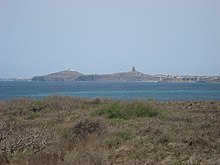
 The Mamelles lighthouse and the Pointe des Almadies seen from the African Renaissance Monument The Mamelles lighthouse and the Pointe des Almadies seen from the African Renaissance Monument | |
| Highest point | |
| Elevation | 105 m (344 ft) |
| Listing | Breast-shaped hills |
| Coordinates | 14°43′22″N 17°29′56″W / 14.72278°N 17.49889°W / 14.72278; -17.49889 |
| Geography | |
 | |
| Climbing | |
| First ascent | Unknown |
| Easiest route | From the Pointe des Almadies, Dakar |

Deux Mamelles, Collines des Mamelles, or simply Mamelles are twin hills located in Ouakam, a suburban commune of Dakar, in the Cap-Vert peninsula, Senegal.
These hills are of volcanic origin and they are the vestiges of a plateau from the early Quaternary. The highest hill is only 105 metres (344 ft) high, but they stand out in the landscape owing to the flat surroundings. The name of these breast-shaped hills comes from the French term “Mamelle”, a name commonly applied in the French-speaking parts of the world to a breast.
On the seaward hill stands a lighthouse, the Phare des Mamelles, while on the hill further ashore the African Renaissance Monument was erected and unveiled in 2010.
See also
References
- Ali Abdallah, Sur une bombe volcanique des Mamelles (Presqu'île du Cap-Vert, Sénégal), in Notes africaines, number 118, April 1968, p. 58-60
- Atlas du Sénégal, Éditions J. A., Paris, 2007, p. 60
- Pinnacle Mountain State Park - Encyclopedia of Arkansas