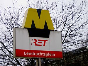
| Eendrachtsplein[REDACTED] | |||||||||||||||||||||
|---|---|---|---|---|---|---|---|---|---|---|---|---|---|---|---|---|---|---|---|---|---|
| Rotterdam Metro station | |||||||||||||||||||||
 | |||||||||||||||||||||
| General information | |||||||||||||||||||||
| Coordinates | 51°54′59″N 4°28′25″E / 51.91639°N 4.47361°E / 51.91639; 4.47361 | ||||||||||||||||||||
| Owned by | RET | ||||||||||||||||||||
| Tracks | 2 | ||||||||||||||||||||
| History | |||||||||||||||||||||
| Opened | 1982 | ||||||||||||||||||||
| Services | |||||||||||||||||||||
| |||||||||||||||||||||
Eendrachtsplein is an underground subway station in the center of Rotterdam. It is part of the Rotterdam Metro lines A, B, and C. The station is named after Eendracht Square (which is Eendrachtsplein in Dutch). It was opened on 10 May 1982. The station is located near several cultural hotspots, of which photos and location information are displayed on information panels on the station walls.
The station is between Dijkzigt and Beurs on the East-West Line (formerly Caland line). Nowadays lines A, B, and C serve the station.
References
- Stiksma, Kees (1987). Tunnels in the Netherlands: Underground Transport Connections. Illustra. ISBN 978-90-6618-536-4.
- Zuid-Holland and Utrecht (Rough Guides Snapshot Netherlands). Rough Guides UK. 2016-04-01. ISBN 978-0-241-27684-6.
- Europe 2000: Expert Advice and Smart Choices, Completely Updated Every Year, Plus a Full-Size Color Map. Fodor's Travel Publications. 1999. ISBN 978-0-679-00328-1.
- Hoogendoorn-Lanser, Sascha (2005). Modelling Travel Behaviour in Multi-modal Networks. Netherlands TRAIL Research School. ISBN 978-90-5584-064-9.
This South Holland location article is a stub. You can help Misplaced Pages by expanding it. |
This Rotterdam Metro-related article is a stub. You can help Misplaced Pages by expanding it. |