| Location | |
|---|---|
 | |
| Location | Strafford / Thetford, Orange County |
| State | Vermont |
| Country | United States |
| Coordinates | 43°48′46″N 72°20′06″W / 43.8128532°N 72.335100°W / 43.8128532; -72.335100 |
| Production | |
| Products | Copper |
| Type | open-pit, underground |
| History | |
| Opened | 1809 (1809) |
| Closed | 1957 |
| Superfund site | |
| Information | |
| CERCLIS ID | VTD988366621 |
| Contaminants | Mine tailings, metals, sulfides |
| Progress | |
| Proposed | December 1, 2000 |
| Listed | June 14, 2001 |
| List of Superfund sites | |

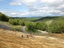
The Elizabeth Mine was a copper mine located on the town line between the Town of Strafford and the Town of Thetford, in Orange County, Vermont.
The ore deposit was discovered in 1793, but mining did not start until 1809. Open pit mining and from 1886 underground mining was conducted. The mine produced up to 8,500,000 pounds (3,900,000 kg) of copper (1954) and was closed in 1957.
Due to acid mine drainage the west branch of the Ompompanoosuc River was polluted. Since 2000 the Environmental Protection Agency (EPA) and the Vermont Agency of Natural Resources have been developing a plan to clean up the area.
Geology
The ore deposits at the Elizabeth Mine represent classic examples of sedimentary exhalative type deposition where hydrothermal fluids enter the marine environment and precipitate out minerals in a strataform ore body. The ores are hosted in the strongly deformed Lower Devonian Gile Mountain Formation (a grey to dark grey mica schist). The ore body at the Elizabeth Mine is a massive sulfide deposit consisting primarily of pyrrhotite and chalcopyrite.
See also
References
- Hammarstrom, J. M.; Seal, R. R. II; Ouimetter, A. P.; Foster, S. A. (2001). "Sources of metals and acidity at the Elizabeth and Ely mines". Society of Economic Geologists Guidebook Series. 35: 213–248.
- Seal, R. R. II; Hammarstrom, J. M.; Slack, J. F.; Hathaway, E. M.; Lovely, W. P.; Kierstead, M. A. (2001). "Introduction: environmental geochemistry and mining history of massive sulfide deposits in the Vermont copper belt". Society of Economic Geologists Guidebook Series. 35: 115–117.
- Deb, M. (2004). Sediment Hosted Lead-Zinc Sulphide Deposits. CRC Press. p. 367.
- Slack, J. F.; Offield, T. W.; Woodruff, L. G.; Shanks, W. C. III (2001). "Geology and geochemistry of Besshi-type massive sulfide deposits of the Vermont copper belt". Society of Economic Geologists Guidebook Series. 35: 193–211.
- Offield, T. W.; Slack, J. F. (1993). "Structure and origin of the Ely copper deposit, east- central Vermont". U.S. Geological Survey Bulletin. 2039: 59–68.
External links
- South Strafford's Elizabeth Copper Mine: The Tyson Years, 1880–1902
- Vermont Mining
- The Geology of the Elizabeth Mine, Peter Howard, 1969
- Geologic Map of the Elizabeth Mine Area (Stratford, VT)
- Historic American Engineering Record (HAER) No. VT-35, "Elizabeth Mine, Mine Road, South Strafford, Orange County, VT", 66 photos, 4 measured drawings, 89 data pages, 11 photo caption pages