| Enciastraia | |
|---|---|
| Tête de l'Enchastraye | |
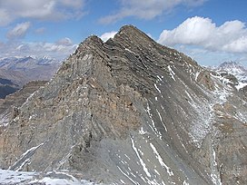
 Enciastraia seen from the Rocca dei Tre Vescovi. Enciastraia seen from the Rocca dei Tre Vescovi. | |
| Highest point | |
| Elevation | 2,955 m (9,695 ft) |
| Prominence | 318 m (1,043 ft) |
| Listing | Alpine mountains 2500-2999 m |
| Coordinates | 44°22′00″N 6°53′24″E / 44.36667°N 6.89000°E / 44.36667; 6.89000 |
| Geography | |
 | |
| Location | Piedmont, Italy Provence-Alpes-Côte d'Azur, France |
| Parent range | Maritime Alps |
Enciastraia (French: Tête de l'Enchastraye) is a mountain in the Maritime Alps, on the boundary between the province of Cuneo (Piedmont, northern Italy) and the French region of Provence-Alpes-Côte-d'Azur.
SOIUSA classification
According to the SOIUSA (International Standardized Mountain Subdivision of the Alps) the mountain can be classified in the following way:
- main part = Western Alps
- major sector = South Western Alps
- section = Maritime Alps
- subsection = (Fr:Alpes Maritimes d.l.s.l./It:Alpi Marittime)
- supergroup = (Fr:Chaîne Corborant-Ténibre-Enchastraye/It:Catena Corborant-Tenibres-Enciastraia)
- group = (Fr:Massif Enchastraye-Siguret/It:Gruppo Enciastraia-Siguret)
- subgroup = (Fr:Groupe de l'Enchastraye/It:Gruppo dell'Enciastraia)
- code = I/A-2.1-C.12.a
References
- "Tête de l'Enchastraye - Peakvisor". peakvisor.co.uk. Retrieved 4 June 2020.
- Marazzi, Sergio (2005). Atlante Orografico delle Alpi. SOIUSA (in Italian). Priuli & Verlucca. p. 71. ISBN 978-88-8068-273-8.
Sources
- Villani, Nanni (April 2002). Monte Argentera, tre metri sotto i tremila e trecento, in Piemonte Parchi - speciale Cime Tempestose. Regione Piemonte.
Maps
- Italian official cartography (Istituto Geografico Militare - IGM); on-line version: www.pcn.minambiente.it
- French official cartography (Institut Géographique National - IGN); on-line version: www.geoportail.fr