| Erentxun | |
|---|---|
| Concejo | |
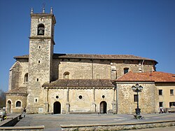
 The church of Erentxun The church of Erentxun | |
   | |
| Coordinates: 42°48′55″N 2°31′19″W / 42.8154141°N 2.52186707°W / 42.8154141; -2.52186707 | |
| Country | Spain |
| Autonomous community | Basque Country |
| Province | Álava |
| Comarca | Llanada Alavesa |
| Municipality | Iruraiz-Gauna |
| Area | |
| • Total | 7.66 km (2.96 sq mi) |
| Elevation | 615 m (2,018 ft) |
| Population | |
| • Total | 85 |
| • Density | 11/km (29/sq mi) |
| Postal code | 01193 |
Erentxun (Spanish: Erenchun) is a hamlet and concejo in the municipality of Iruraiz-Gauna, in Álava province, Basque Country, Spain. Its parish church, dedicated to Saint Andrew, dates from the 13th century.
References
- "Divisiones Administrativas SHP Líneas". GeoAraba. Diputación Foral de Álava. 24 January 2024. Retrieved 15 March 2024.
- "Nomenclátor: Núcleos". Entidades Locales de Álava (in Spanish). Diputación Foral de Álava. 1 January 2023. Retrieved 15 March 2024.
- "Erentxun". Enciclopedia del románico en el País Vasco (PDF) (in Spanish and Basque). Fundación Santa María la Real. 2011. p. 669. ISBN 978-84-15072-54-6.
External links
- [REDACTED] Media related to Erentxun at Wikimedia Commons
This article about a location in the Basque Country, Spain, is a stub. You can help Misplaced Pages by expanding it. |