 No higher resolution available.
'Donkey_Rock',_Broughton-in-Furness_-_geograph.org.uk_-_50803.jpg (640 × 480 pixels, file size: 184 KB, MIME type: image/jpeg)
| [REDACTED] | This is a file from the Wikimedia Commons. Information from its description page there is shown below. Commons is a freely licensed media file repository. You can help. |
Summary
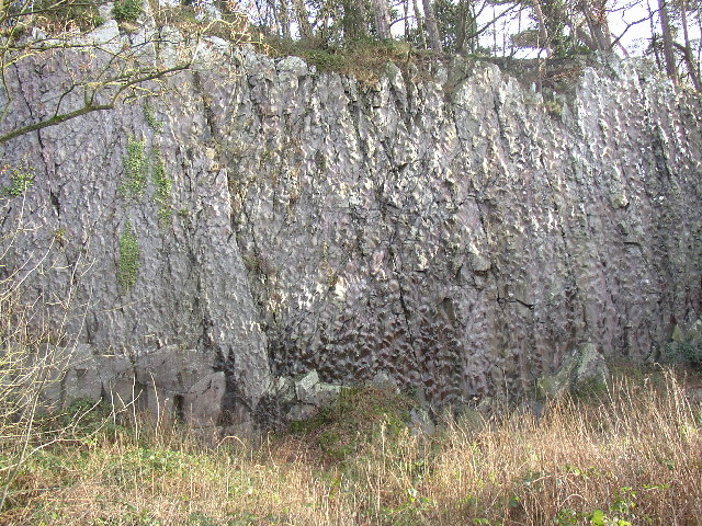
| Description'Donkey Rock', Broughton-in-Furness - geograph.org.uk - 50803.jpg | English: 'Donkey Rock', Broughton-in-Furness. By the roadside at SD210867, Bush Green Quarry has a cliff-face 70m across and 10m high that shows 'sole structures' in the almost vertically bedded turbidite sandstones and mudstones (Coniston Grits) of Silurian age, about 400 million years old. These are knobbly lumps on the surface of the rock, formed by the deposition of hard material on the sea-bed by deep-water currents, and there are more than 1800 of them, mainly types known as flute and load casts, covering six bedding planes (see www.ougsnw.org.uk/photo_gallery/Geoscenes/ Foxfield.html). Further information see Moseley 1978 Geology of the Lake District, p 143, Yorkshire Geological Society. |
| Date | |
| Source | From geograph.org.uk |
| Author | Humphrey Bolton |
| Attribution (required by the license)InfoField | Humphrey Bolton / 'Donkey Rock', Broughton-in-Furness / CC BY-SA 2.0 |
| InfoField | Humphrey Bolton / 'Donkey Rock', Broughton-in-Furness |
| Object location | 54° 16′ N, 3° 13′ W [REDACTED] | View this and other nearby images on: OpenStreetMap |
|---|
Licensing

|
This image was taken from the Geograph project collection. See this photograph's page on the Geograph website for the photographer's contact details. The copyright on this image is owned by Humphrey Bolton and is licensed for reuse under the Creative Commons Attribution-ShareAlike 2.0 license. |
- You are free:
- to share – to copy, distribute and transmit the work
- to remix – to adapt the work
- Under the following conditions:
- attribution – You must give appropriate credit, provide a link to the license, and indicate if changes were made. You may do so in any reasonable manner, but not in any way that suggests the licensor endorses you or your use.
- share alike – If you remix, transform, or build upon the material, you must distribute your contributions under the same or compatible license as the original.
Captions
'Donkey Rock', Broughton-in-FurnessItems portrayed in this file
depicts
Broughton West
creator<\/a>"}},"text\/plain":{"en":{"":"creator"}}},"{\"value\":{\"entity-type\":\"property\",\"numeric-id\":3831,\"id\":\"P3831\"},\"type\":\"wikibase-entityid\"}":{"text\/html":{"en":{"":"object of statement has role<\/a>"}},"text\/plain":{"en":{"":"object of statement has role"}}},"{\"value\":{\"entity-type\":\"item\",\"numeric-id\":33231,\"id\":\"Q33231\"},\"type\":\"wikibase-entityid\"}":{"text\/html":{"en":{"P3831":"photographer<\/a>"}},"text\/plain":{"en":{"P3831":"photographer"}}},"{\"value\":{\"entity-type\":\"property\",\"numeric-id\":2093,\"id\":\"P2093\"},\"type\":\"wikibase-entityid\"}":{"text\/html":{"en":{"":"author name string<\/a>"}},"text\/plain":{"en":{"":"author name string"}}},"{\"value\":\"Humphrey Bolton\",\"type\":\"string\"}":{"text\/html":{"en":{"P2093":"Humphrey Bolton"}},"text\/plain":{"en":{"P2093":"Humphrey Bolton"}}},"{\"value\":{\"entity-type\":\"property\",\"numeric-id\":2699,\"id\":\"P2699\"},\"type\":\"wikibase-entityid\"}":{"text\/html":{"en":{"":"URL<\/a>"}},"text\/plain":{"en":{"":"URL"}}},"{\"value\":\"https:\\\/\\\/www.geograph.org.uk\\\/profile\\\/1712\",\"type\":\"string\"}":{"text\/html":{"en":{"P2699":"https:\/\/www.geograph.org.uk\/profile\/1712<\/a>"}},"text\/plain":{"en":{"P2699":"https:\/\/www.geograph.org.uk\/profile\/1712"}}}}">creator
some value
object of statement has role: photographerauthor name string: Humphrey BoltonURL: https://www.geograph.org.uk/profile/1712copyright status<\/a>"}},"text\/plain":{"en":{"":"copyright status"}}},"{\"value\":{\"entity-type\":\"item\",\"numeric-id\":50423863,\"id\":\"Q50423863\"},\"type\":\"wikibase-entityid\"}":{"text\/html":{"en":{"P6216":"copyrighted<\/a>"}},"text\/plain":{"en":{"P6216":"copyrighted"}}}}">copyright status
copyrighted
copyright license<\/a>"}},"text\/plain":{"en":{"":"copyright license"}}},"{\"value\":{\"entity-type\":\"item\",\"numeric-id\":19068220,\"id\":\"Q19068220\"},\"type\":\"wikibase-entityid\"}":{"text\/html":{"en":{"P275":"Creative Commons Attribution-ShareAlike 2.0 Generic<\/a>"}},"text\/plain":{"en":{"P275":"Creative Commons Attribution-ShareAlike 2.0 Generic"}}},"{\"value\":{\"entity-type\":\"property\",\"numeric-id\":1476,\"id\":\"P1476\"},\"type\":\"wikibase-entityid\"}":{"text\/html":{"en":{"":"title<\/a>"}},"text\/plain":{"en":{"":"title"}}},"{\"value\":{\"text\":\"'Donkey Rock', Broughton-in-Furness\",\"language\":\"en\"},\"type\":\"monolingualtext\"}":{"text\/html":{"en":{"P1476":"'Donkey Rock', Broughton-in-Furness<\/span> (English)<\/span>"}},"text\/plain":{"en":{"P1476":"'Donkey Rock', Broughton-in-Furness"}}},"{\"value\":{\"entity-type\":\"property\",\"numeric-id\":2093,\"id\":\"P2093\"},\"type\":\"wikibase-entityid\"}":{"text\/html":{"en":{"":"author name string<\/a>"}},"text\/plain":{"en":{"":"author name string"}}},"{\"value\":\"Humphrey Bolton\",\"type\":\"string\"}":{"text\/html":{"en":{"P2093":"Humphrey Bolton"}},"text\/plain":{"en":{"P2093":"Humphrey Bolton"}}}}">copyright license
Creative Commons Attribution-ShareAlike 2.0 Generic
title: 'Donkey Rock', Broughton-in-Furness (English)author name string: Humphrey Boltonsource of file<\/a>"}},"text\/plain":{"en":{"":"source of file"}}},"{\"value\":{\"entity-type\":\"item\",\"numeric-id\":74228490,\"id\":\"Q74228490\"},\"type\":\"wikibase-entityid\"}":{"text\/html":{"en":{"P7482":"file available on the internet<\/a>"}},"text\/plain":{"en":{"P7482":"file available on the internet"}}},"{\"value\":{\"entity-type\":\"property\",\"numeric-id\":7384,\"id\":\"P7384\"},\"type\":\"wikibase-entityid\"}":{"text\/html":{"en":{"":"geograph.org.uk image ID<\/a>"}},"text\/plain":{"en":{"":"geograph.org.uk image ID"}}},"{\"value\":\"50803\",\"type\":\"string\"}":{"text\/html":{"en":{"P7384":"50803<\/a>"}},"text\/plain":{"en":{"P7384":"50803"}}},"{\"value\":{\"entity-type\":\"property\",\"numeric-id\":137,\"id\":\"P137\"},\"type\":\"wikibase-entityid\"}":{"text\/html":{"en":{"":"operator<\/a>"}},"text\/plain":{"en":{"":"operator"}}},"{\"value\":{\"entity-type\":\"item\",\"numeric-id\":1503119,\"id\":\"Q1503119\"},\"type\":\"wikibase-entityid\"}":{"text\/html":{"en":{"P137":"Geograph Britain and Ireland<\/a>"}},"text\/plain":{"en":{"P137":"Geograph Britain and Ireland"}}},"{\"value\":{\"entity-type\":\"property\",\"numeric-id\":973,\"id\":\"P973\"},\"type\":\"wikibase-entityid\"}":{"text\/html":{"en":{"":"described at URL<\/a>"}},"text\/plain":{"en":{"":"described at URL"}}},"{\"value\":\"https:\\\/\\\/www.geograph.org.uk\\\/photo\\\/50803\",\"type\":\"string\"}":{"text\/html":{"en":{"P973":"https:\/\/www.geograph.org.uk\/photo\/50803<\/a>"}},"text\/plain":{"en":{"P973":"https:\/\/www.geograph.org.uk\/photo\/50803"}}}}">source of file
file available on the internet
geograph.org.uk image ID: 50803operator: Geograph Britain and Irelanddescribed at URL: https://www.geograph.org.uk/photo/50803inception<\/a>"}},"text\/plain":{"en":{"":"inception"}}},"{\"value\":{\"time\":\"+2004-01-26T00:00:00Z\",\"timezone\":0,\"before\":0,\"after\":0,\"precision\":11,\"calendarmodel\":\"http:\\\/\\\/www.wikidata.org\\\/entity\\\/Q1985727\"},\"type\":\"time\"}":{"text\/html":{"en":{"P571":"26 January 2004"}},"text\/plain":{"en":{"P571":"26 January 2004"}}}}">inception
26 January 2004
coordinates of depicted place<\/a>"}},"text\/plain":{"en":{"":"coordinates of depicted place"}}},"{\"value\":{\"latitude\":54.268,\"longitude\":-3.21,\"altitude\":null,\"precision\":0.001,\"globe\":\"http:\\\/\\\/www.wikidata.org\\\/entity\\\/Q2\"},\"type\":\"globecoordinate\"}":{"text\/html":{"en":{"P9149":"54\u00b016'5"N, 3\u00b012'36"W"}},"text\/plain":{"en":{"P9149":"54\u00b016'5\"N, 3\u00b012'36\"W"}}}}">coordinates of depicted place
54°16'5"N, 3°12'36"W
media type<\/a>"}},"text\/plain":{"en":{"":"media type"}}},"{\"value\":\"image\\\/jpeg\",\"type\":\"string\"}":{"text\/html":{"en":{"P1163":"image\/jpeg"}},"text\/plain":{"en":{"P1163":"image\/jpeg"}}}}">media type
image/jpeg
checksum<\/a>"}},"text\/plain":{"en":{"":"checksum"}}},"{\"value\":\"b147f3293ce5d9e3e1924ee1ece94406cc56a2dd\",\"type\":\"string\"}":{"text\/html":{"en":{"P4092":"b147f3293ce5d9e3e1924ee1ece94406cc56a2dd"}},"text\/plain":{"en":{"P4092":"b147f3293ce5d9e3e1924ee1ece94406cc56a2dd"}}},"{\"value\":{\"entity-type\":\"property\",\"numeric-id\":459,\"id\":\"P459\"},\"type\":\"wikibase-entityid\"}":{"text\/html":{"en":{"":"determination method or standard<\/a>"}},"text\/plain":{"en":{"":"determination method or standard"}}},"{\"value\":{\"entity-type\":\"item\",\"numeric-id\":13414952,\"id\":\"Q13414952\"},\"type\":\"wikibase-entityid\"}":{"text\/html":{"en":{"P459":"SHA-1<\/a>"}},"text\/plain":{"en":{"P459":"SHA-1"}}}}">checksum
b147f3293ce5d9e3e1924ee1ece94406cc56a2dd
determination method or standard: SHA-1data size<\/a>"}},"text\/plain":{"en":{"":"data size"}}},"{\"value\":{\"amount\":\"+188325\",\"unit\":\"http:\\\/\\\/www.wikidata.org\\\/entity\\\/Q8799\"},\"type\":\"quantity\"}":{"text\/html":{"en":{"P3575":"188,325 byte<\/span>"}},"text\/plain":{"en":{"P3575":"188,325 byte"}}}}">data size
188,325 byte
height<\/a>"}},"text\/plain":{"en":{"":"height"}}},"{\"value\":{\"amount\":\"+480\",\"unit\":\"http:\\\/\\\/www.wikidata.org\\\/entity\\\/Q355198\"},\"type\":\"quantity\"}":{"text\/html":{"en":{"P2048":"480 pixel<\/span>"}},"text\/plain":{"en":{"P2048":"480 pixel"}}}}">height
480 pixel
width<\/a>"}},"text\/plain":{"en":{"":"width"}}},"{\"value\":{\"amount\":\"+640\",\"unit\":\"http:\\\/\\\/www.wikidata.org\\\/entity\\\/Q355198\"},\"type\":\"quantity\"}":{"text\/html":{"en":{"P2049":"640 pixel<\/span>"}},"text\/plain":{"en":{"P2049":"640 pixel"}}}}">width
640 pixel
exposure time<\/a>"}},"text\/plain":{"en":{"":"exposure time"}}},"{\"value\":{\"amount\":\"+0.0166666666666667\",\"unit\":\"http:\\\/\\\/www.wikidata.org\\\/entity\\\/Q11574\"},\"type\":\"quantity\"}":{"text\/html":{"en":{"P6757":"0.0166666666666667 second<\/span>"}},"text\/plain":{"en":{"P6757":"0.0166666666666667 second"}}}}">exposure time
0.0166666666666667 second
f-number<\/a>"}},"text\/plain":{"en":{"":"f-number"}}},"{\"value\":{\"amount\":\"+2.9\",\"unit\":\"1\"},\"type\":\"quantity\"}":{"text\/html":{"en":{"P6790":"2.9"}},"text\/plain":{"en":{"P6790":"2.9"}}}}">f-number
2.9
ISO speed<\/a>"}},"text\/plain":{"en":{"":"ISO speed"}}},"{\"value\":{\"amount\":\"+60\",\"unit\":\"1\"},\"type\":\"quantity\"}":{"text\/html":{"en":{"P6789":"60"}},"text\/plain":{"en":{"P6789":"60"}}}}">ISO speed
60
instance of<\/a>"}},"text\/plain":{"en":{"":"instance of"}}},"{\"value\":{\"entity-type\":\"item\",\"numeric-id\":125191,\"id\":\"Q125191\"},\"type\":\"wikibase-entityid\"}":{"text\/html":{"en":{"P31":"photograph<\/a>"}},"text\/plain":{"en":{"P31":"photograph"}}}}">instance of
photograph
focal length<\/a>"}},"text\/plain":{"en":{"":"focal length"}}},"{\"value\":{\"amount\":\"+6\",\"unit\":\"http:\\\/\\\/www.wikidata.org\\\/entity\\\/Q174789\"},\"type\":\"quantity\"}":{"text\/html":{"en":{"P2151":"6 millimetre<\/span>"}},"text\/plain":{"en":{"P2151":"6 millimetre"}}}}">focal length
6 millimetre
geograph.org.uk image ID<\/a>"}},"text\/plain":{"en":{"":"geograph.org.uk image ID"}}},"{\"value\":\"50803\",\"type\":\"string\"}":{"text\/html":{"en":{"P7384":"50803<\/a>"}},"text\/plain":{"en":{"P7384":"50803"}}}}">geograph.org.uk image ID
50803
location of creation<\/a>"}},"text\/plain":{"en":{"":"location of creation"}}},"{\"value\":{\"entity-type\":\"item\",\"numeric-id\":651122,\"id\":\"Q651122\"},\"type\":\"wikibase-entityid\"}":{"text\/html":{"en":{"P1071":"Broughton West<\/a>"}},"text\/plain":{"en":{"P1071":"Broughton West"}}}}">location of creation
Broughton West
File history
Click on a date/time to view the file as it appeared at that time.
| Date/Time | Thumbnail | Dimensions | User | Comment | |
|---|---|---|---|---|---|
| current | 12:40, 30 January 2010 |  | 640 × 480 (184 KB) | GeographBot | == {{int:filedesc}} == {{Information |description={{en|1='Donkey Rock', Broughton-in-Furness. By the roadside at SD210867, Bush Green Quarry has a cliff-face 70m across and 10m high that shows 'sole structures' in the almost vertically bedded turbidite sa |
File usage
The following page uses this file:
Metadata
This file contains additional information, probably added from the digital camera or scanner used to create or digitize it.
If the file has been modified from its original state, some details may not fully reflect the modified file.
| Image title | OLYMPUS DIGITAL CAMERA |
|---|---|
| Camera manufacturer | OLYMPUS OPTICAL CO.,LTD |
| Camera model | C300Z,D550Z |
| Exposure time | 1/60 sec (0.016666666666667) |
| F-number | f/2.9 |
| ISO speed rating | 60 |
| Date and time of data generation | Unknown date |
| Lens focal length | 6 mm |
| Orientation | Normal |
| Horizontal resolution | 72 dpi |
| Vertical resolution | 72 dpi |
| Software used | v574p-76 |
| File change date and time | Unknown date |
| Y and C positioning | Co-sited |
| Exposure Program | Normal program |
| Exif version | 2.1 |
| Date and time of digitizing | Unknown date |
| Meaning of each component |
|
| Image compression mode | 1 |
| Exposure bias | 0 |
| Maximum land aperture | 3.1 APEX (f/2.93) |
| Metering mode | Pattern |
| Light source | Unknown |
| Flash | Flash did not fire |
| Supported Flashpix version | 1 |
| Color space | sRGB |
| File source | Digital still camera |
| Scene type | A directly photographed image |