 No higher resolution available.
'Isle_of_Inishmore'_and_'Jonathan_Swift'_in_Belfast_-_geograph.org.uk_-_653773.jpg (640 × 508 pixels, file size: 73 KB, MIME type: image/jpeg)
| This is a file from the Wikimedia Commons. Information from its description page there is shown below. Commons is a freely licensed media file repository. You can help. |
Summary
| Description'Isle of Inishmore' and 'Jonathan Swift' in Belfast - geograph.org.uk - 653773.jpg |
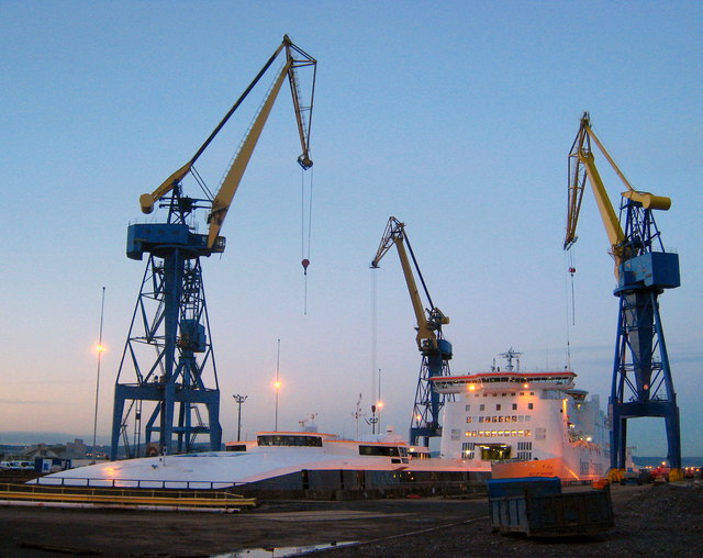
English: 'Isle of Inishmore' and 'Jonathan Swift' in Belfast. The Irish Ferries operated vessels 'Jonathan Swift' and 'Isle of Inishmore', seen here in dry dock at Harland and Wolff in Belfast.
To the foreground is the 'Jonathan Swift', a small fast ferry that operates on the Dublin-Holyhead route. Only the top of her is visible in this picture. Behind is the 'Isle of Inishmore', a larger conventional RORO ferry that operates on the Rosslare-Pembroke route. See http://www.irishferries.com/ships/index.shtml for more information on the vessels and the routes they operate. 597088 gives a good example of the 'Inishmore' at work. See http://www.irishships.com/dry_dock_belfast_2008.htm (IrishShips.com) for some related images. See also 647985 |
| Date | |
| Source | From geograph.org.uk |
| Author | Ross |
| Camera location | 54° 37′ 08″ N, 5° 53′ 31″ W | View this and other nearby images on: OpenStreetMap |
|---|
| Object location | 54° 37′ 12″ N, 5° 53′ 34″ W | View this and other nearby images on: OpenStreetMap |
|---|
Licensing

|
This image was taken from the Geograph project collection. See this photograph's page on the Geograph website for the photographer's contact details. The copyright on this image is owned by Ross and is licensed for reuse under the Creative Commons Attribution-ShareAlike 2.0 license. |
- You are free:
- to share – to copy, distribute and transmit the work
- to remix – to adapt the work
- Under the following conditions:
- attribution – You must give appropriate credit, provide a link to the license, and indicate if changes were made. You may do so in any reasonable manner, but not in any way that suggests the licensor endorses you or your use.
- share alike – If you remix, transform, or build upon the material, you must distribute your contributions under the same or compatible license as the original.
Captions
'Isle of Inishmore' and 'Jonathan Swift' in BelfastItems portrayed in this file
depicts
dock
Belfast
creator<\/a>"}},"text\/plain":{"en":{"":"creator"}}},"{\"value\":{\"entity-type\":\"property\",\"numeric-id\":2093,\"id\":\"P2093\"},\"type\":\"wikibase-entityid\"}":{"text\/html":{"en":{"":"author name string<\/a>"}},"text\/plain":{"en":{"":"author name string"}}},"{\"value\":\"Ross\",\"type\":\"string\"}":{"text\/html":{"en":{"P2093":"Ross"}},"text\/plain":{"en":{"P2093":"Ross"}}},"{\"value\":{\"entity-type\":\"property\",\"numeric-id\":2699,\"id\":\"P2699\"},\"type\":\"wikibase-entityid\"}":{"text\/html":{"en":{"":"URL<\/a>"}},"text\/plain":{"en":{"":"URL"}}},"{\"value\":\"https:\\\/\\\/www.geograph.org.uk\\\/profile\\\/12869\",\"type\":\"string\"}":{"text\/html":{"en":{"P2699":"https:\/\/www.geograph.org.uk\/profile\/12869<\/a>"}},"text\/plain":{"en":{"P2699":"https:\/\/www.geograph.org.uk\/profile\/12869"}}},"{\"value\":{\"entity-type\":\"property\",\"numeric-id\":3831,\"id\":\"P3831\"},\"type\":\"wikibase-entityid\"}":{"text\/html":{"en":{"":"object of statement has role<\/a>"}},"text\/plain":{"en":{"":"object of statement has role"}}},"{\"value\":{\"entity-type\":\"item\",\"numeric-id\":33231,\"id\":\"Q33231\"},\"type\":\"wikibase-entityid\"}":{"text\/html":{"en":{"P3831":"photographer<\/a>"}},"text\/plain":{"en":{"P3831":"photographer"}}}}">creator
some value
author name string: RossURL: https://www.geograph.org.uk/profile/12869object of statement has role: photographercopyright status<\/a>"}},"text\/plain":{"en":{"":"copyright status"}}},"{\"value\":{\"entity-type\":\"item\",\"numeric-id\":50423863,\"id\":\"Q50423863\"},\"type\":\"wikibase-entityid\"}":{"text\/html":{"en":{"P6216":"copyrighted<\/a>"}},"text\/plain":{"en":{"P6216":"copyrighted"}}}}">copyright status
copyrighted
copyright license<\/a>"}},"text\/plain":{"en":{"":"copyright license"}}},"{\"value\":{\"entity-type\":\"item\",\"numeric-id\":19068220,\"id\":\"Q19068220\"},\"type\":\"wikibase-entityid\"}":{"text\/html":{"en":{"P275":"Creative Commons Attribution-ShareAlike 2.0 Generic<\/a>"}},"text\/plain":{"en":{"P275":"Creative Commons Attribution-ShareAlike 2.0 Generic"}}},"{\"value\":{\"entity-type\":\"property\",\"numeric-id\":1476,\"id\":\"P1476\"},\"type\":\"wikibase-entityid\"}":{"text\/html":{"en":{"":"title<\/a>"}},"text\/plain":{"en":{"":"title"}}},"{\"value\":{\"text\":\"'Isle of Inishmore' and 'Jonathan Swift' in Belfast\",\"language\":\"en\"},\"type\":\"monolingualtext\"}":{"text\/html":{"en":{"P1476":"'Isle of Inishmore' and 'Jonathan Swift' in Belfast<\/span> (English)<\/span>"}},"text\/plain":{"en":{"P1476":"'Isle of Inishmore' and 'Jonathan Swift' in Belfast"}}},"{\"value\":{\"entity-type\":\"property\",\"numeric-id\":2093,\"id\":\"P2093\"},\"type\":\"wikibase-entityid\"}":{"text\/html":{"en":{"":"author name string<\/a>"}},"text\/plain":{"en":{"":"author name string"}}},"{\"value\":\"Rossographer\",\"type\":\"string\"}":{"text\/html":{"en":{"P2093":"Rossographer"}},"text\/plain":{"en":{"P2093":"Rossographer"}}}}">copyright license
Creative Commons Attribution-ShareAlike 2.0 Generic
title: 'Isle of Inishmore' and 'Jonathan Swift' in Belfast (English)author name string: Rossographersource of file<\/a>"}},"text\/plain":{"en":{"":"source of file"}}},"{\"value\":{\"entity-type\":\"item\",\"numeric-id\":74228490,\"id\":\"Q74228490\"},\"type\":\"wikibase-entityid\"}":{"text\/html":{"en":{"P7482":"file available on the internet<\/a>"}},"text\/plain":{"en":{"P7482":"file available on the internet"}}},"{\"value\":{\"entity-type\":\"property\",\"numeric-id\":7384,\"id\":\"P7384\"},\"type\":\"wikibase-entityid\"}":{"text\/html":{"en":{"":"geograph.org.uk image ID<\/a>"}},"text\/plain":{"en":{"":"geograph.org.uk image ID"}}},"{\"value\":\"653773\",\"type\":\"string\"}":{"text\/html":{"en":{"P7384":"653773<\/a>"}},"text\/plain":{"en":{"P7384":"653773"}}},"{\"value\":{\"entity-type\":\"property\",\"numeric-id\":137,\"id\":\"P137\"},\"type\":\"wikibase-entityid\"}":{"text\/html":{"en":{"":"operator<\/a>"}},"text\/plain":{"en":{"":"operator"}}},"{\"value\":{\"entity-type\":\"item\",\"numeric-id\":1503119,\"id\":\"Q1503119\"},\"type\":\"wikibase-entityid\"}":{"text\/html":{"en":{"P137":"Geograph Britain and Ireland<\/a>"}},"text\/plain":{"en":{"P137":"Geograph Britain and Ireland"}}},"{\"value\":{\"entity-type\":\"property\",\"numeric-id\":973,\"id\":\"P973\"},\"type\":\"wikibase-entityid\"}":{"text\/html":{"en":{"":"described at URL<\/a>"}},"text\/plain":{"en":{"":"described at URL"}}},"{\"value\":\"https:\\\/\\\/www.geograph.org.uk\\\/photo\\\/653773\",\"type\":\"string\"}":{"text\/html":{"en":{"P973":"https:\/\/www.geograph.org.uk\/photo\/653773<\/a>"}},"text\/plain":{"en":{"P973":"https:\/\/www.geograph.org.uk\/photo\/653773"}}}}">source of file
file available on the internet
geograph.org.uk image ID: 653773operator: Geograph Britain and Irelanddescribed at URL: https://www.geograph.org.uk/photo/653773inception<\/a>"}},"text\/plain":{"en":{"":"inception"}}},"{\"value\":{\"time\":\"+2008-01-09T00:00:00Z\",\"timezone\":0,\"before\":0,\"after\":0,\"precision\":11,\"calendarmodel\":\"http:\\\/\\\/www.wikidata.org\\\/entity\\\/Q1985727\"},\"type\":\"time\"}":{"text\/html":{"en":{"P571":"9 January 2008"}},"text\/plain":{"en":{"P571":"9 January 2008"}}}}">inception
9 January 2008
coordinates of the point of view<\/a>"}},"text\/plain":{"en":{"":"coordinates of the point of view"}}},"{\"value\":{\"latitude\":54.61899,\"longitude\":-5.8919,\"altitude\":null,\"precision\":1.0e-5,\"globe\":\"http:\\\/\\\/www.wikidata.org\\\/entity\\\/Q2\"},\"type\":\"globecoordinate\"}":{"text\/html":{"en":{"P1259":"54\u00b037'8.36"N, 5\u00b053'30.84"W"}},"text\/plain":{"en":{"P1259":"54\u00b037'8.36\"N, 5\u00b053'30.84\"W"}}},"{\"value\":{\"entity-type\":\"property\",\"numeric-id\":7787,\"id\":\"P7787\"},\"type\":\"wikibase-entityid\"}":{"text\/html":{"en":{"":"heading<\/a>"}},"text\/plain":{"en":{"":"heading"}}},"{\"value\":{\"amount\":\"+337\",\"unit\":\"http:\\\/\\\/www.wikidata.org\\\/entity\\\/Q28390\"},\"type\":\"quantity\"}":{"text\/html":{"en":{"P7787":"337 degree<\/span>"}},"text\/plain":{"en":{"P7787":"337 degree"}}}}">coordinates of the point of view
54°37'8.36"N, 5°53'30.84"W
heading: 337 degreecoordinates of depicted place<\/a>"}},"text\/plain":{"en":{"":"coordinates of depicted place"}}},"{\"value\":{\"latitude\":54.62008,\"longitude\":-5.8928,\"altitude\":null,\"precision\":1.0e-5,\"globe\":\"http:\\\/\\\/www.wikidata.org\\\/entity\\\/Q2\"},\"type\":\"globecoordinate\"}":{"text\/html":{"en":{"P9149":"54\u00b037'12.29"N, 5\u00b053'34.08"W"}},"text\/plain":{"en":{"P9149":"54\u00b037'12.29\"N, 5\u00b053'34.08\"W"}}},"{\"value\":{\"entity-type\":\"property\",\"numeric-id\":7787,\"id\":\"P7787\"},\"type\":\"wikibase-entityid\"}":{"text\/html":{"en":{"":"heading<\/a>"}},"text\/plain":{"en":{"":"heading"}}},"{\"value\":{\"amount\":\"+337\",\"unit\":\"http:\\\/\\\/www.wikidata.org\\\/entity\\\/Q28390\"},\"type\":\"quantity\"}":{"text\/html":{"en":{"P7787":"337 degree<\/span>"}},"text\/plain":{"en":{"P7787":"337 degree"}}}}">coordinates of depicted place
54°37'12.29"N, 5°53'34.08"W
heading: 337 degreemedia type<\/a>"}},"text\/plain":{"en":{"":"media type"}}},"{\"value\":\"image\\\/jpeg\",\"type\":\"string\"}":{"text\/html":{"en":{"P1163":"image\/jpeg"}},"text\/plain":{"en":{"P1163":"image\/jpeg"}}}}">media type
image/jpeg
checksum<\/a>"}},"text\/plain":{"en":{"":"checksum"}}},"{\"value\":\"3b2558558aba2cc16d37d30c93a1715de3e5406e\",\"type\":\"string\"}":{"text\/html":{"en":{"P4092":"3b2558558aba2cc16d37d30c93a1715de3e5406e"}},"text\/plain":{"en":{"P4092":"3b2558558aba2cc16d37d30c93a1715de3e5406e"}}},"{\"value\":{\"entity-type\":\"property\",\"numeric-id\":459,\"id\":\"P459\"},\"type\":\"wikibase-entityid\"}":{"text\/html":{"en":{"":"determination method or standard<\/a>"}},"text\/plain":{"en":{"":"determination method or standard"}}},"{\"value\":{\"entity-type\":\"item\",\"numeric-id\":13414952,\"id\":\"Q13414952\"},\"type\":\"wikibase-entityid\"}":{"text\/html":{"en":{"P459":"SHA-1<\/a>"}},"text\/plain":{"en":{"P459":"SHA-1"}}}}">checksum
3b2558558aba2cc16d37d30c93a1715de3e5406e
determination method or standard: SHA-1data size<\/a>"}},"text\/plain":{"en":{"":"data size"}}},"{\"value\":{\"amount\":\"+74579\",\"unit\":\"http:\\\/\\\/www.wikidata.org\\\/entity\\\/Q8799\"},\"type\":\"quantity\"}":{"text\/html":{"en":{"P3575":"74,579 byte<\/span>"}},"text\/plain":{"en":{"P3575":"74,579 byte"}}}}">data size
74,579 byte
height<\/a>"}},"text\/plain":{"en":{"":"height"}}},"{\"value\":{\"amount\":\"+508\",\"unit\":\"http:\\\/\\\/www.wikidata.org\\\/entity\\\/Q355198\"},\"type\":\"quantity\"}":{"text\/html":{"en":{"P2048":"508 pixel<\/span>"}},"text\/plain":{"en":{"P2048":"508 pixel"}}}}">height
508 pixel
width<\/a>"}},"text\/plain":{"en":{"":"width"}}},"{\"value\":{\"amount\":\"+640\",\"unit\":\"http:\\\/\\\/www.wikidata.org\\\/entity\\\/Q355198\"},\"type\":\"quantity\"}":{"text\/html":{"en":{"P2049":"640 pixel<\/span>"}},"text\/plain":{"en":{"P2049":"640 pixel"}}}}">width
640 pixel
geograph.org.uk image ID<\/a>"}},"text\/plain":{"en":{"":"geograph.org.uk image ID"}}},"{\"value\":\"653773\",\"type\":\"string\"}":{"text\/html":{"en":{"P7384":"653773<\/a>"}},"text\/plain":{"en":{"P7384":"653773"}}}}">geograph.org.uk image ID
653773
instance of<\/a>"}},"text\/plain":{"en":{"":"instance of"}}},"{\"value\":{\"entity-type\":\"item\",\"numeric-id\":125191,\"id\":\"Q125191\"},\"type\":\"wikibase-entityid\"}":{"text\/html":{"en":{"P31":"photograph<\/a>"}},"text\/plain":{"en":{"P31":"photograph"}}}}">instance of
photograph
location of creation<\/a>"}},"text\/plain":{"en":{"":"location of creation"}}},"{\"value\":{\"entity-type\":\"item\",\"numeric-id\":10686,\"id\":\"Q10686\"},\"type\":\"wikibase-entityid\"}":{"text\/html":{"en":{"P1071":"Belfast<\/a>"}},"text\/plain":{"en":{"P1071":"Belfast"}}}}">location of creation
Belfast
File history
Click on a date/time to view the file as it appeared at that time.
| Date/Time | Thumbnail | Dimensions | User | Comment | |
|---|---|---|---|---|---|
| current | 13:59, 7 February 2011 |  | 640 × 508 (73 KB) | GeographBot | == {{int:filedesc}} == {{Information |description={{en|1='Isle of Inishmore' and 'Jonathan Swift' in Belfast The Irish Ferries operated vessels 'Jonathan Swift' and 'Isle of Inishmore', seen here in dry dock at Harland and Wolff in Belfast. To the for |
File usage
The following page uses this file:
Global file usage
The following other wikis use this file:
- Usage on af.wikipedia.org
- Usage on th.wikipedia.org