 Size of this preview: 800 × 589 pixels. Other resolutions: 320 × 236 pixels | 640 × 472 pixels | 1,024 × 755 pixels | 1,280 × 943 pixels | 2,560 × 1,886 pixels | 4,876 × 3,593 pixels.
Original file (4,876 × 3,593 pixels, file size: 39.75 MB, MIME type: image/jpeg)
| This is a file from the Wikimedia Commons. Information from its description page there is shown below. Commons is a freely licensed media file repository. You can help. |
Summary
| Description용산시가도.jpg |
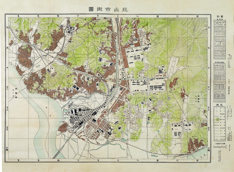
한국어: <용산시가도龍山市街圖>는 1927년에 발행한 1:7,500 지도로서 용산 일본군기지와 용산역 및 주변의 철도기지 등을 자세히 살펴볼 수 있는 지도이다. <경성시가도京城市街圖(1927)>와는 저작권소유자와 인쇄자 및 판매자 등이 모두 같다. 용산시가도가 경성시가도와 별도로 제작된 것은 철도와 병영 신시가지로 조성된 신용산이 갖고 있는 독립적인 시가지 특성 때문이다.
또한 방안方眼이 표시되어 있으며, 시가지에는 지번地番을 작은 글씨로 적어 놓았고, 주요 건물들을 건물모양 대로 그려 놓았으며, 지도 좌측에는 색인(정동리와 관청·회사·학교 등)과 범례가 실려 있다. 이러한 지도 형식은 <경성시가도>와 같은데, 방안의 가로·세로에 쓰여진 숫자와 글씨에 맞춰 서로 이어 붙여볼 수 있게 하였다. 그러나 <경성시가도>와는 달리 산악이 등고선으로 표시되어 있다. 남산 아래 필동에 있던 일본군사령부가 신용산으로 이전된 것은 1908년이었으며, 군사기지에는 사격장·사령부청사·사령관관저·육군병원·병영·병기창·관사·연병장·육군형무소·탄약고 등 각종 시설물들이 가득 들어섰다. 이 기지는 1931년의 만주강점과 1937년의 중일전쟁을 계기로 더욱 강화되었고, 1941년 제2차 세계대전 발발로 더욱 요새화되었다. 용산의 일본군 병영 중심에 위치한 보병영은 해방후 용산에 주둔한 주한미군의 메인포스트로 사용되었으며, 메인포스트의 서측 지역이 한국에 반환되면서 전쟁기념관이 건립되었다. 그리고 경인철도 부설과 함께 철도기지화가 진행되었던 용산역 근처에는 구획 정리된 신시가지와 함께 철도국·철도선·차고·발전소·수리창·관사·철도병원 등 철도관련 시설이 집중되어 있다. |
| Date | |
| Source | 서울역사박물관 |
| Creator | Unknown authorUnknown author |
| Georeferencing | Georeference the map in Wikimaps Warper If inappropriate please set warp_status = skip to hide. |
Licensing

|
This file is licensed under the Korea Open Government License Type I: Attribution. |
| Attribution: 서울역사박물관 | |
http://www.kogl.or.kr/open/info/license_info/by.doKOGL Type 1공공누리 제1유형 출처 표시truetrue |
| ||||||||||
| This work may also be in the public domain in the Democratic People's Republic of Korea, depending the date of the death of its creator and the jurisdiction that it belongs; in that case, you may also add {{PD-North Korea}}.
Notice: If the work has been first published outside of Korea, you should apply a country-specific license tag rather than this license one. For photographic works, please use {{PD-Korea-1910-1945-photo}}; for motion picture (films) works, please use {{PD-Korea-1910-1945-film}}. |
Captions
Add a one-line explanation of what this file representsItems portrayed in this file
depicts
inception<\/a>"}},"text\/plain":{"en":{"":"inception"}}},"{\"value\":{\"time\":\"+1927-01-01T00:00:00Z\",\"timezone\":0,\"before\":0,\"after\":0,\"precision\":9,\"calendarmodel\":\"http:\\\/\\\/www.wikidata.org\\\/entity\\\/Q1985727\"},\"type\":\"time\"}":{"text\/html":{"en":{"P571":"1927"}},"text\/plain":{"en":{"P571":"1927"}}}}">inception
1927
File history
Click on a date/time to view the file as it appeared at that time.
| Date/Time | Thumbnail | Dimensions | User | Comment | |
|---|---|---|---|---|---|
| current | 00:27, 23 March 2021 |  | 4,876 × 3,593 (39.75 MB) | Sadopaul | Uploaded a work by unknown from with UploadWizard |
File usage
The following page uses this file:
Global file usage
The following other wikis use this file:
Metadata
This file contains additional information, probably added from the digital camera or scanner used to create or digitize it.
If the file has been modified from its original state, some details may not fully reflect the modified file.
| Image title |
|
|---|---|
| Orientation | Normal |
| Horizontal resolution | 118.1102 dpc |
| Vertical resolution | 118.1102 dpc |
| Software used | Adobe Photoshop CS4 Windows |
| File change date and time | 23:08, 14 December 2010 |
| Color space | Uncalibrated |
| Image width | 4,876 px |
| Image height | 3,593 px |
| Unique ID of original document | uuid:22C754D57FC7DF119A92CF5A454BAA4A |
| Date and time of digitizing | 20:02, 24 September 2010 |
| Date metadata was last modified | 08:08, 15 December 2010 |
| IIM version | 2 |

