 Filipino–American Friendship Highway
 | ||||
|---|---|---|---|---|
| Friendship Circumferential Road | ||||
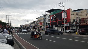
 The Fil-Am Friendship Highway in the Koreatown area of Angeles City The Fil-Am Friendship Highway in the Koreatown area of Angeles City | ||||
| Route information | ||||
| Maintained by the Department of Public Works and Highways – Pampanga 1st District Engineering Office and Pampanga 3rd District Engineering Office | ||||
| Component highways | ||||
| Major junctions | ||||
| North end | Don Juico Avenue in Angeles City | |||
| Major intersections |
| |||
| South end | ||||
| Location | ||||
| Country | Philippines | |||
| Provinces | Pampanga | |||
| Major cities | Angeles City and San Fernando | |||
| Highway system | ||||
| ||||
| ||||
The Filipino–American Friendship Highway, officially the Friendship Circumferential Road (or simply the Friendship Highway), is a secondary national road traversing the cities of Angeles City and San Fernando in Pampanga, Philippines.
The entire highway is designated as National Route 216 (N216) of the Philippine highway network.
External links
- [REDACTED] Media related to Filipino–American Friendship Highway at Wikimedia Commons
References
- "Pampanga 1st". www.dpwh.gov.ph. Retrieved 2018-09-09.
- "Pampanga 3rd". www.dpwh.gov.ph. Retrieved 2018-09-09.
| Major roads in Pampanga | |||||
|---|---|---|---|---|---|
| Expressways |
| ||||
| National roads |
| ||||
This Philippine road or road transport-related article is a stub. You can help Misplaced Pages by expanding it. |