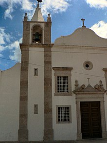
| Frielas | |
|---|---|
| Civil parish | |
 Coat of arms Coat of arms | |
 | |
| Coordinates: 38°49′33″N 09°08′40″W / 38.82583°N 9.14444°W / 38.82583; -9.14444 | |
| Country | |
| Region | Lisbon |
| Metropolitan area | Lisbon |
| District | Lisbon |
| Municipality | Loures |
| Disbanded | 2013 |
| Area | |
| • Total | 5.63 km (2.17 sq mi) |
| Population | |
| • Total | 2,676 |
| • Density | 480/km (1,200/sq mi) |
| Time zone | UTC+00:00 (WET) |
| • Summer (DST) | UTC+01:00 (WEST) |
| Postal code | 2670 |

Frielas (Portuguese pronunciation: [fɾiˈɛlɐʃ]) is a former civil parish in the municipality of Loures, Lisbon District, Portugal. In 2013, the parish merged into the new parish Santo António dos Cavaleiros e Frielas. Frielas has an area of 5.63 km, 2676 inhabitants according to the census made in 2001 and a density of 475 inhabitants per km.
References
- Diário da República. "Law nr. 11-A/2013, page 552 62" (PDF) (in Portuguese). Retrieved 24 July 2014.
This Lisbon location article is a stub. You can help Misplaced Pages by expanding it. |