| This article relies largely or entirely on a single source. Relevant discussion may be found on the talk page. Please help improve this article by introducing citations to additional sources. Find sources: "Hamswehrum" – news · newspapers · books · scholar · JSTOR (October 2023) |
| Hamswehrum | |
|---|---|
| Village of Krummhörn | |
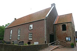
 St. Maria's Church St. Maria's Church | |
 Coat of arms Coat of arms | |
| Location of Hamswehrum | |
  | |
| Coordinates: 53°25′51″N 7°02′59″E / 53.43077°N 7.04963°E / 53.43077; 7.04963 | |
| Country | Germany |
| State | Lower Saxony |
| District | Aurich |
| Municipality | Krummhörn |
| Area | |
| • Metro | 6.46 km (2.49 sq mi) |
| Elevation | 5 m (16 ft) |
| Population | |
| • Metro | 469 |
| Time zone | UTC+01:00 (CET) |
| • Summer (DST) | UTC+02:00 (CEST) |
| Postal codes | 26736 |
| Dialling codes | 04923 |
Hamswehrum is a village in the region of East Frisia, in Lower Saxony, Germany. It is part of the municipality of Krummhörn. The village is located between Upleward and Groothusen.
The village is first mentioned in a written source in 1375 and was probably founded by the inhabitants of a disappeared place (Hamswehr or Hayenswehr). Buildings such as the Geele Börg ('Yellow Castle') appear repeatedly in the history of the place. Nowadays, only a farm named after this castle remains a reminder of this. The 15th-century church was demolished in 1967 and replaced by a new church, St. Maria's Church, the following year.
References
- "Hamswehrum". Greetsiel-Krummhoern.de (in German). Retrieved 17 October 2023.
External links
[REDACTED] Media related to Hamswehrum at Wikimedia Commons
| Villages in the municipality of Krummhörn | ||
|---|---|---|