Misplaced Pages

Hardy Pond

Article snapshot taken from[REDACTED] with creative commons attribution-sharealike license. Give it a read and then ask your questions in the chat. We can research this topic together.
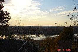
Pond in Waltham, Massachusetts, US
Hardy Pond
Location of Hardy Pond in Massachusetts, USA.Location of Hardy Pond in Massachusetts, USA.Hardy PondShow map of MassachusettsLocation of Hardy Pond in Massachusetts, USA.Location of Hardy Pond in Massachusetts, USA.Hardy PondShow map of the United States
LocationWaltham, Massachusetts
Coordinates42°24′26.53″N 71°14′38.26″W / 42.4073694°N 71.2439611°W / 42.4073694; -71.2439611
Basin countriesUnited States
Surface area42 acres (17 ha)

Hardy Pond is a 45-acre (180,000 m) pond located in Waltham, Massachusetts. Originally almost twice the size, in recent times the pond level was lowered in an inappropriate approach to controlling flooding. The quality of the water has degraded due to eutrophication caused by run-off from roads, fertilizers, and storm drain inputs. The pond is contiguous with 35 acres (140,000 m) of adjoining wetlands. It is a popular site for bird sightings, with over 140 species listed.

External links

Lakes and ponds of Massachusetts by drainage system
Lakes
Connecticut River Watershed
Housatonic River Watershed
Merrimack River Watershed
Providence River Watershed
Taunton River Watershed
Others
Ponds
Agawam River Watershed
Connecticut River Watershed
Eel River Watershed
Jones River Watershed
Mattapoisett River Watershed
Merrimack River Watershed
Taunton River Watershed
Wankinco River Watershed
Others


Stub icon

This Middlesex County, Massachusetts geography–related article is a stub. You can help Misplaced Pages by expanding it.

Categories:
Hardy Pond Add topic