| Herran | |
|---|---|
| Locality | |
 | |
  | |
| Coordinates: 43°23′5″N 4°6′38″W / 43.38472°N 4.11056°W / 43.38472; -4.11056 | |
| Country | |
| Autonomous community | |
| Province | |
| Municipality | Santillana del Mar |
| Dimensions | |
| • Width | 36 km (22 mi) |
| Elevation | 80 m (260 ft) |
| Population | |
| • Total | 263 |
| Demonym | vivedense |
| Time zone | UTC+1 (CET) |
| • Summer (DST) | UTC+2 (CEST) |
| Postal code | 39360 |
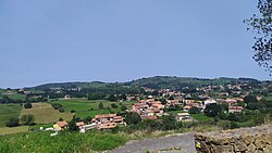
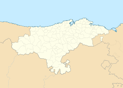
Herrán is a town in the municipality of Santillana del Mar (Cantabria, Spain), where the Cave of Altamira has been a World Heritage Site since 1985 and a protected archaeological site since April 25, 1924. It is located about six hundred meters south of the municipal capital, Santillana del Mar. It is located 80 meters above sea level. As of 2009, the population was 212 (INE 2009). It is next to Camplengo. It is one of the localities where vestiges of the Roman occupation of the area have been found: a tombstone in the church. The first historical reference to the town, recorded in the cartulary of the Abbey of Santillana, dates from 1223. In the c. 15th century was the jurisdiction of the Casa de la Vega, with headquarters in what is now Torrelavega.
In addition to its hamlet, developed especially between the c. 16th century and c. 17th century, highlights the hermitage of San Sebastián, a building late Gothic of the c. 14th century located in a field near the village. An excavation at the site brought to light the altar base of an earlier hermitage, dated between the c. 9th century and c. 10th century. The stone is actually the Roman slab cited, from the c. 3rd century, where the letters STTI (in Latin: sit tibi terra levis; "May the earth be light to you").
This town is accessed by means of the regional road CA-134 and the public transport line Santillana de Mar - Barreda has its beginning in this town.
Demographics
| 2000 | 2001 | 2002 | 2003 | 2004 | 2005 | 2006 | 2007 | 2008 | 2009 | 2015 | 2020 |
|---|---|---|---|---|---|---|---|---|---|---|---|
| 178 | 186 | 185 | 195 | 204 | 209 | 204 | 214 | 209 | 212 | 255 | 263 |
Source: INE
References
- "Instituto Nacional de Estadística. (Spanish Statistical Institute)". www.ine.es. Retrieved 2021-09-08.
- Municipal Register of Spain 2018. National Statistics Institute.
- Ministry of Public Works, Housing and Urban Planning of the Government of Cantabria. "Catálogo de la Red Autonómica de Cantabria". Retrieved September 21, 2018.
- Ministry of Innovation, Industry, Tourism and Commerce of the Government of Cantabria. "Portal Transporte de Cantabria". Retrieved October 17, 2020.
{{cite web}}: CS1 maint: multiple names: authors list (link) Result of the search with origin Herrán. - "INE: Viveda". Archived from the original on September 20, 2011. Retrieved July 2, 2010.