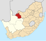
Place in Northern Cape, South Africa
| Heuningvlei TsoeCoe | |
|---|---|
  | |
| Coordinates: 26°17′28″S 23°10′55″E / 26.291°S 23.182°E / -26.291; 23.182 | |
| Country | South Africa |
| Province | Northern Cape |
| District | John Taolo Gaetsewe |
| Municipality | Joe Morolong |
| Area | |
| • Total | 7.90 km (3.05 sq mi) |
| Population | |
| • Total | 2,656 |
| • Density | 340/km (870/sq mi) |
| Racial makeup (2011) | |
| • Black African | 98.9% |
| • Coloured | 0.3% |
| • Indian/Asian | 0.6% |
| • White | 0.2% |
| • Other | 0.1% |
| First languages (2011) | |
| • Tswana | 92.8% |
| • S. Ndebele | 2.3% |
| • English | 1.6% |
| • Other | 3.2% |
| Time zone | UTC+2 (SAST) |
| Postal code (street) | 8611 |
| Area code | 05492 |
Heuningvlei is a village in Joe Morolong Local Municipality in the Northern Cape province of South Africa. The name means "the hollow of the bees where water gathers".
Heuningvlei was formerly owned by Turner & Newall. Blue asbestos was mined at Heuningvlei until 1979, and many local residents suffer from asbestos-related diseases.
References
- ^ "Main Place Heuningvlei". Census 2011.
- ^ "Multinational Asbestos Miners Have Left a Trail of Deadly Fiber and Dying Workers in South Africa". Multinational Monitor, March 1982. Retrieved 26 July 2014.
- "Heuningvlei Asbestos Interest Group". Health Systems Trust. Archived from the original on 12 August 2014. Retrieved 26 July 2014.
| Municipalities and communities of John Taolo Gaetsewe District Municipality, Northern Cape | ||
|---|---|---|
| District seat: Kuruman | ||
| Joe Morolong |  | |
| Ga-Segonyana | ||
| Gamagara | ||
This Northern Cape location article is a stub. You can help Misplaced Pages by expanding it. |