| Hollywood and Vine | |
|---|---|
| Prospect and Weyse Avenues (1887–1910) | |
 Hollywood and Vine street signs Hollywood and Vine street signs | |
| Location | |
| Hollywood, Los Angeles | |
| Coordinates | 34°06′06″N 118°19′36″W / 34.10167°N 118.32667°W / 34.10167; -118.32667 |
| Roads at junction | Hollywood Boulevard Vine Street |
| Construction | |
| Type | Intersection |
| Opened | 1887 (as Prospect and Weyse) 1910 (as Hollywood and Vine) |
| Maintained by | City of Los Angeles Department of Public Works |
Hollywood and Vine, the intersection of Hollywood Boulevard and Vine Street in Hollywood, California, became known in the 1920s for its concentration of radio and movie-related businesses. The Hollywood Walk of Fame is centered on the intersection.
History
 Aerial view of Hollywood and Vine, 1920
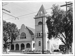
The area was a lemon grove until 1903, when Daeida Beveridge allowed one corner of the dirt intersection on her property to be used for the Hollywood Memorial Church. The streets were renamed in 1910, when the city of Hollywood was annexed into Los Angeles.
Beginning in the 1920s, during the Golden Age of Hollywood, the area began to see an influx of money and influence as movie and music businesses moved to the district, turning the local farms and orchards into movie backlots. Hollywood and Vine was the second busiest intersection in the city, after Wilshire Boulevard and Western Avenue.
In the 1930s, radio station KFWB spoke of "broadcasting live from Hollywood and Vine," and newspaper columnists Hedda Hopper and Jimmie Fidler regularly touted the intersection's mystique.
In 1958, the intersection became the crossing point of the newly installed t-shaped Hollywood Walk of Fame. Later Neil Armstrong, Buzz Aldrin and Michael Collins, the astronauts of the first lunar landing mission Apollo 11, were awarded television stars for coverage of the mission, and given the places of honor at all four corners of Hollywood and Vine.
By the 1960s, however, many studios and broadcasters had moved onto more upscale areas, and the area fell into disrepair and disrepute, with many abandoned stores and offices, and the streets themselves, claimed by squatters and panhandlers. It took several decades for redevelopment to take hold, and visitors looking for Hollywood dreams were often taken aback by the area's contrast with shinier tourist meccas.

The Hollywood/Vine subway station opened in 1999, and led to more sustained and serious redevelopment in the area. On May 29, 2003, Hollywood and Vine was named "Bob Hope Square" to commemorate Hope's 100th birthday.
In urban folklore, many of the local buildings are considered to be part of "Haunted Hollywood", home to the ghosts of celebrities (and less stellar residents) of Hollywood's legendary past. The intersection has been mentioned or alluded to in dozens of songs, films, video games, music videos and other popular media, often as a symbol of Hollywood's lure as a destination for dreamers, or for its decadence and disappointments.
Historic buildings
Hollywood and Vine's first building, located on the intersection's sourtheast corner, was the Hollywood Memorial Church, constructed in 1903. It was later torn down to make way for the intersection's first high rise, the 12-story Taft Building, built in 1923. The Taft Building was built in the Renaissance Revival style for A.Z. Taft Jr. by Walker & Eisen. In Hollywood's golden age, every studio as well as Charlie Chaplin, Will Rogers, and the Academy of Motion Picture Arts and Sciences had offices in the building. To the south of the Taft Building is the Spanish Colonial Revival Herman Building and south of that was the complementary-designed Hollywood Brown Derby, the latter of which was demolished in 1994. To the east of the Taft Building was the Châteauesque Gilbert Books Building, which was demolished to make way for the W Hollywood Hotel and Residences.
On the northeast corner, the Equitable Building of Hollywood was designed by Aleck Curlett, built in 1929, and expanded in 1931. Originally home to numerous talent and advertising agencies, it was converted to a condominium in 2007. East of the Equitable Building is the Art Deco Hollywood Pantages Theatre, designed by B. Marcus Priteca and built as a movie palace in 1930, then converted to a live theater in the 1977. North of the Equitable Building is the Welton Becket designed, Googie-styled Capitol Records Building. Built in 1956, the Capitol Records Building is the world's first circular office building and was home to the first record label location on the west coast of the United States.
On the northwest corner, the Laemmle Building was built in 1932 by Richard Neutra for Carl Laemmle, head of Universal Pictures. The original design was not built because of the 1929 stock market crash, and the building was significantly altered many times. The building was gutted by fire in April 2008 and razed six months later. To the west of the former Laemmle Building is the former site of Sardi's Diner and is now home to the Cave Theater. West of that is the Vine Theatre. To the north of the former Laemmle Building is a Spanish Colonial style Hollywood Playhouse, opened on January 24, 1927 designed by H. L. Gogerty and Carl Jules Weyl. The building's name has changed many times over the 20th century, but was known as the Hollywood Palace for many years before its most recent renaming.
On the southwest corner, the Dyas Building was built in 1927 by Frederick Rice Dorn. From 1931 to 1982, the building housed The Broadway-Hollywood department store, and in 2007, the building converted to multi-family residential, ground-floor commercial. The Dyas Building has two annexes, one to the south of the building and the other to the west, that were built in the late 1930s. South of the building is the Hollywood Plaza Hotel, built by Walker & Eisen in 1924 and at one point home to silent film star Clara Bow's "It Cafe".
Six of the aforementioned buildings are listed as Los Angeles Historic-Cultural Monuments:
- Hollywood Pantages Theatre (#193)
- Broadway Hollywood Building (#664)
- Hollywood Plaza Hotel (#665)
- Taft Building (#666)
- Capitol Records Building (#857)
- Equitable Building (#1088)
Furthermore, nine of the aforementioned buildings are listed as contributing properties in the National Register of Historic Places Hollywood Boulevard Commercial and Entertainment District:
- Hollywood Pantages Theatre
- Broadway Hollywood Building
- Hollywood Plaza Hotel
- Taft Building
- Equitable Building
- Hollywood Playhouse
- Herman Building
- Gilbert Books
- Hollywood Brown Derby
-
 Hollywood Memorial Church (1903-1923) in 1905
-
Taft Building (Los Angeles) (1923-) in 2006
-
 Hollywood Plaza Hotel (1924-) in 2015
-
 Hollywood Playhouse (1927-) in 1927
-
 Broadway Hollywood Building (1928-) in 2016
-
 Herman Building (1928-) in 2024
-
Hollywood Brown Derby building (1929-1994) in the 1950s
-
 Equitable Building of Hollywood (1929/1931-) in 2014
-
 Hollywood Pantages Theatre (1930-) in 2012
-
 Vine Theatre (1940-) in 2008
-
 Capitol Records Building (1956-) in 2008
Redevelopment and urbanization
A number of high-profile projects have attempted to restore the lost luster of the area, most notably the $600 million W Hollywood Hotel and Residences, which opened in 2010. Other large projects include a $50-million conversion of the Equitable Building and $70-million conversion of the Dyas Building into condominiums.
References
- ^ "Early Views of Hollywood (1850–1920)". Water and Power Associates. p. 1. Retrieved July 29, 2024.
- Torrence, Bruce (1982). Hollywood. The First Hundred Years. New York Zoetrope. ISBN 0918432448.
- ^ Pool, Bob. "Turning the corner at Hollywood and Vine" Los Angeles Times, May 4, 2008
- "Star Map". Hollywood Chamber of Commerce. Retrieved August 11, 2024.
- "Hollywood Star Walk: Apollo Landing". Los Angeles Times. Retrieved May 18, 2011.
- "Metro Rail - Past and Future In Los Angeles" (PDF). Los Angeles County Metropolitan Transportation Authority. Retrieved July 28, 2024.
- "Comedian Bob Hope dies". BBC News. July 28, 2003. Archived from the original on October 23, 2012. Retrieved August 18, 2012.
- ^ "National Register of Historic Places Inventory Nomination Form - Hollywood Boulevard Commercial and Entertainment District". United States Department of the Interior - National Park Service. April 4, 1985.
- "The Taft Building". Academy of Motion Picture Arts and Sciences. Retrieved July 23, 2024.
- "Early Los Angeles Historical Buildings (1925 +)". Water and Power Associates. p. 6. Retrieved July 23, 2024.
- Maher, Adrian (February 15, 1994). "Broken Hearts as Brown Derby Is Demolished". Los Angeles Times.
- "Historic-Cultural Monument Application for the Bank of Hollywood/Equitable Building" (PDF). City of Los Angeles. March 19, 2015.
- Wanamaker, Marc. "The Equitable Building of Hollywood". hollywoodheritage.com. Retrieved July 1, 2024.
- ^ "Early Los Angeles Historical Buildings (1925 +)". Water and Power Associates. p. 3. Retrieved July 1, 2024.
- "Pantages Theatre (Hollywood)". Water and Power Associates. Retrieved July 20, 2024.
- "Capitol Records Building Remains a Star". adg lighting. October 9, 2019.
- "World's First Circular Building Readied Here". Los Angeles Times (1923-1955). April 8, 1956. ProQuest 166913154. Retrieved 10 June 2020.
- Huell Howser; Sue Satriano (1988). Exploring L.A. with Huell (video). Hollywood, California: KCET. Archived from the original (mp3) on 8 December 2007. Retrieved 22 September 2010.
- "Early Los Angeles Historical Buildings (1925 +)". Water and Power Associates. p. 4. Retrieved July 21, 2024.
- "Historic L.A."
- "Resource Report". City of Los Angeles. Retrieved 24 April 2024.
- "Early Los Angeles Historical Buildings (1925 +)". Water and Power Associates. p. 2. Retrieved July 28, 2024.
- "Hollywood Plaza Hotel - Vine St. and Hollywood Blvd. Hollywood California". Our Changing Landscape. April 22, 2016.
- "Historic-Cultural Monument (HCM) List" (PDF). City of Los Angeles. Retrieved Oct 10, 2020.
- Christopher Hawthorne (January 29, 2010). "The W Hollywood Hotel & Residences: An urban complexity". Los Angeles Times.
- Zach Behrens (January 27, 2010). "The W Hollywood Hotel in Hollywood Opens Today". LAist.
- Vincent, Roger (2005-09-13). "Broadway Building Gets Loft Conversion". Los Angeles Times. Retrieved 2014-08-07.
External links
- Hollywood Entertainment District
- Hollywood Boulevard - myth & reality
- Historic Resources Group - Historic LA Project
| Greater Hollywood | |||||||||||||||||||||||
|---|---|---|---|---|---|---|---|---|---|---|---|---|---|---|---|---|---|---|---|---|---|---|---|
| Districts and neighborhoods | |||||||||||||||||||||||
| Businesses |
| ||||||||||||||||||||||
| Other points of interest |
| ||||||||||||||||||||||
| Transportation |
| ||||||||||||||||||||||
| Neighboring cities and communities | |||||||||||||||||||||||
| Hollywood Boulevard Commercial and Entertainment District | |||||
|---|---|---|---|---|---|
| Contributing properties |
| ||||
| Removed from contributing | |||||
| Non- contributing | |||||
| Mentioned but not listed | |||||
| Featured architects |
| ||||
| Other individuals | |||||
| Related topics | |||||