Town in South Carolina, United States
| Irmo, South Carolina | |
|---|---|
| Town | |
 | |
 Flag Flag Seal Seal | |
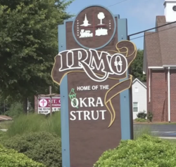
| Motto(s): "Gateway to Lake Murray and Home of the Okra Strut" | |
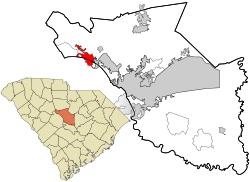
 Location in Richland County and the state of South Carolina. Location in Richland County and the state of South Carolina. | |
| Coordinates: 34°05′10″N 81°10′59″W / 34.08611°N 81.18306°W / 34.08611; -81.18306 | |
| Country | United States |
| State | South Carolina |
| Counties | Lexington, Richland |
| Incorporated | December 24, 1890 |
| Named for | C.J. Iredell and H.C. Mosely |
| Government | |
| • Mayor | Bill Danielson |
| • Town Administrator | Courtney Dennis |
| Area | |
| • Total | 6.86 sq mi (17.77 km) |
| • Land | 6.86 sq mi (17.77 km) |
| • Water | 0.00 sq mi (0.00 km) |
| Elevation | 358 ft (109 m) |
| Population | |
| • Total | 11,569 |
| • Density | 1,660.54/sq mi (641.10/km) |
| Time zone | UTC-5 (EST) |
| • Summer (DST) | UTC-4 (EDT) |
| ZIP code | 29063 |
| Area code(s) | 803, 839 |
| FIPS code | 45-35890 |
| GNIS feature ID | 1231420 |
| Demonym | Irmite |
| Website | www |
Irmo (/ˈərmoʊ/) is a town in Lexington and Richland counties, South Carolina, United States and a suburb of Columbia. It is part of the Columbia Metropolitan Statistical Area and is located 12 miles (19 km) northwest of the city center. The population of Irmo was 11,569 at the 2020 census.
History
Irmo was chartered on Christmas Eve in 1890 in response to the opening of the Columbia, Newberry and Laurens Railroad. The name of Irmo was the result of combining the names of Captain C.J. Iredell and Henry Moseley, two important figures in the founding of the town.
Geography
According to the United States Census Bureau, the town has a total area of 6.86 square miles (17.8 km), all land.
Demographics
| Census | Pop. | Note | %± |
|---|---|---|---|
| 1900 | 193 | — | |
| 1910 | 267 | 38.3% | |
| 1920 | 236 | −11.6% | |
| 1930 | 365 | 54.7% | |
| 1940 | 230 | −37.0% | |
| 1950 | 281 | 22.2% | |
| 1960 | 359 | 27.8% | |
| 1970 | 517 | 44.0% | |
| 1980 | 3,957 | 665.4% | |
| 1990 | 11,280 | 185.1% | |
| 2000 | 11,039 | −2.1% | |
| 2010 | 11,097 | 0.5% | |
| 2020 | 11,569 | 4.3% | |
| U.S. Decennial Census | |||
2020 census
| Race | Num. | Perc. |
|---|---|---|
| White (non-Hispanic) | 6,466 | 55.89% |
| Black or African American (non-Hispanic) | 3,518 | 30.41% |
| Native American | 42 | 0.36% |
| Asian | 241 | 2.08% |
| Pacific Islander | 29 | 0.25% |
| Other/Mixed | 610 | 5.27% |
| Hispanic or Latino | 663 | 5.73% |
As of the 2020 United States census, there were 11,569 people, 4,686 households, and 3,327 families residing in the town.
As of 2023, of the 11,519 people, about 7,550 are in Richland County and about 4,019 are in Lexington County.
2000 census
As of the census of 2000, there are 11,039 people, 3,911 households, and 3,163 families residing in the town. The population density is 1,032.0/km² (2,670.2/mi²). There are 4,066 housing units at an average density of 380.1/km² (983.5/mi²). The racial makeup of the town is 76.76% White, 20.16% African American, 0.25% Native American, 1.43% Asian, 0.08% Pacific Islander, 0.44% from other races, and 0.88% from two or more races. 1.42% of the population are Hispanic or Latino of any race.
There were 3,911 households, out of which 47.7% had children under the age of 18 living with them, 65.9% were married couples living together, 12.0% had a female householder with no husband present, and 19.1% were non-families. 15.4% of all households were made up of individuals, and 2.6% had someone living alone who was 65 years of age or older. The average household size was 2.81 and the average family size was 3.15.
In the town, the population was spread out, with 30.7% under the age of 18, 6.6% from 18 to 24, 34.6% from 25 to 44, 23.3% from 45 to 64, and 4.8% who were 65 years of age or older. The median age was 34 years. For every 100 females, there were 93.6 males. For every 100 females age 18 and over, there were 88.7 males.
The median income for a household in the town was $55,847, and the median income for a family was $62,005. Males had a median income of $41,054 versus $30,171 for females. The per capita income for the town was $22,312. About 3.3% of families and 4.3% of the population were below the poverty line, including 4.4% of those under age 18 and 11.6% of those age 65 or over.
Arts and culture

The Okra Strut is an annual festival started in 1973 as a fundraising effort for a new library. Named for the okra plant, events have included a charity golf tournament, street dance, live entertainment, a midway, cycling and running competitions, arts and crafts exhibits, and a parade.
The Jacob Wingard Dreher House is listed on the National Register of Historic Places.
Irmo has two public libraries, a branch of the Lexington County Public Library and a branch of the Richland County Public Library.
Government
As of March 2024, the town council includes:
- Bill Danielson - Mayor
- Erik Sickinger - Mayor Pro-Tem
- Barb Waldman - Council Member
- Phyllis Coleman - Council Member
- Gabriel Penfield - Council Member
A town administrator, responsible primarily for the efficient operation of the town government, is appointed by the town council.
Education
The school district is Lexington School District 5 for all parts of Irmo.
Schools in the city limits include:
- Irmo Elementary School serves grades K-5.
- H. E. Corley Elementary School
- Dutch Fork Elementary School
Schools in proximity to Irmo, with "Irmo" in their names, and/or with Irmo postal addresses, but not in the city limits:
- Crossroads Intermediate School serves grade 6.
- Irmo Middle School serves grades 6-8.
- Irmo High School serves grades 9-12.
- Dutch Fork Middle School serves grades 7-8
- Dutch Fork High School serves Grades 9-12.
Notable people
- Tyler Bass (born 1997) NFL kicker for Buffalo Bills, attended Dutch Fork High School
- Ben Bridwell (born 1978), singer for Band of Horses
- Alaina Coates (born 1995), professional basketball player for the Chicago Sky
- Danny Efland (born 1988), racing driver
- Leeza Gibbons (born 1957), talk show host
- Jalin Hyatt (born 2001), NFL wide receiver for the New York Giants
- Dustin Johnson (born 1984), professional golfer; attended Dutch Fork High School
- B.J. McKie (born 1977), minor league basketball player University of South Carolina
- Courtney Shealy (born 1977), swimmer, 2000 Olympic Gold Medalist
- E. Lee Spence (born 1947), pioneer underwater archaeologist and shipwreck historian
- Auden Tate (born 1997), NFL wide receiver for the Atlanta Falcons
- Ian McCurdy (born 1971) Atlantic Records/Mammoth Records A&R Representative. Working with the likes of Seven Mary Three and Squirrel Nut Zippers
References
- "Irmo". South Carolina Encyclopedia. Retrieved November 27, 2023.
- ^ "QuickFacts: Irmo town, South Carolina". United States Census Bureau. Retrieved February 17, 2024.
- ^ U.S. Geological Survey Geographic Names Information System: Irmo, South Carolina
- ^ "Census Population API". United States Census Bureau. Retrieved October 15, 2022.
- "U.S. Census website". United States Census Bureau. Archived from the original on December 27, 1996. Retrieved January 31, 2008.
- "Census of Population and Housing". Census.gov. Archived from the original on April 26, 2015. Retrieved June 4, 2015.
- "Explore Census Data". data.census.gov. Retrieved December 13, 2021.
- "General Highway System Lexington County, South Carolina" (PDF). South Carolina Department of Transportation. February 2023. Retrieved October 25, 2024.
- "The Irmo Okra Strut". Town of Irmo. Archived from the original on December 30, 2017. Retrieved December 30, 2017.
- "National Register Information System". National Register of Historic Places. National Park Service. March 13, 2009.
- "Locations". Lexington County Public Library. Retrieved September 28, 2022.
- "Council Directory". Town of Irmo, South Carolina. Retrieved December 16, 2023.
- "Town Council". Town of Irmo, South Carolina. Retrieved December 16, 2023.
- "2020 CENSUS - SCHOOL DISTRICT REFERENCE MAP: Richland County, SC" (PDF). U.S. Census Bureau. Retrieved October 25, 2024. - Text list
- "2020 CENSUS - SCHOOL DISTRICT REFERENCE MAP: Lexington County, SC" (PDF). U.S. Census Bureau. Retrieved October 25, 2024. - Text list
- "Irmo Elementary / Homepage". Retrieved August 12, 2020.
- ^ "General Highway System Lexington County, South Carolina" (PDF). South Carolina Department of Transportation. February 2023. Retrieved October 25, 2024. - The schools are not directly shown on the map, but comparing their locations with the map shows they are not in the Irmo city limits.
- ^ "General Highway System Richland County, South Carolina" (PDF). South Carolina Department of Transportation. June 2023. Retrieved October 25, 2024. - The school is not directly shown on the map, but comparing its location with the map shows it is not in the Irmo city limits.
External links
| Municipalities and communities of Lexington County, South Carolina, United States | ||
|---|---|---|
| County seat: Lexington | ||
| Cities |  | |
| Towns | ||
| CDPs | ||
| Ghost town | ||
| Footnotes | ‡This populated place also has portions in an adjacent county or counties | |
| Municipalities and communities of Richland County, South Carolina, United States | ||
|---|---|---|
| County seat: Columbia | ||
| Cities |  | |
| Towns | ||
| CDPs | ||
| Other communities | ||
| Footnotes | ||