| This article needs additional citations for verification. Please help improve this article by adding citations to reliable sources. Unsourced material may be challenged and removed. Find sources: "Isla del Congreso" – news · newspapers · books · scholar · JSTOR (August 2017) (Learn how and when to remove this message) |
 | |
| Geography | |
|---|---|
| Archipelago | Chafarinas Islands |
| Adjacent to | Mediterranean Sea |
| Area | 0.256 km (0.099 sq mi) |
| Coastline | 3 km (1.9 mi) |
| Highest elevation | 137 m (449 ft) |
| Administration | |
| Spain | |
| Demographics | |
| Population | 0 |
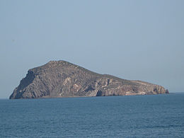
The Isla del Congreso (in English: Congress Island) is an island located in the Chafarinas Islands, an archipelago located 4 kilometers from the African shore. The island belongs to Spain, and has an area of 0.256 km.
Geography
The island is uninhabited. It has some rabbits and a pigeon colony. The west coast is very inaccessible, with very steep cliffs, while the east coast is more accessible. The island is very rocky, with very little grass or plants. There is one navigable cave.
References
- Guo, Rongxing (2006). Territorial Disputes and Resource Management: A Global Handbook. Nova Publishers. p. 80.
35°10′44″N 2°26′29″W / 35.17889°N 2.44139°W / 35.17889; -2.44139
This article about a location in Spain's autonomous north African cities or Plazas de soberanía is a stub. You can help Misplaced Pages by expanding it. |