 | |
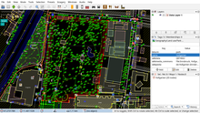
 JOSM with single OpenStreetMap data layer displayed JOSM with single OpenStreetMap data layer displayed | |
| Original author(s) | Immanuel Scholz |
|---|---|
| Developer(s) | Dirk Stöcker and other contributors |
| Initial release | January 22, 2006; 18 years ago (2006-01-22) |
| Stable release | 19265 |
| Repository | |
| Written in | Java |
| Platform | Cross-platform |
| Available in | 38 languages |
| Type | GIS software |
| License | GNU GPL v2 |
| Website | josm |
JOSM (listen) (Java OpenStreetMap editor) is a free software desktop editing tool for OpenStreetMap geodata created in Java, originally developed by Immanuel Scholz and currently maintained by Dirk Stöcker. The editing tool contains advanced features that are not present in OSM's default online editor, iD.
Features

Some notable features of JOSM are importing GPX files (GPS tracks), working with aerial imagery (including WMS, TMS and WMTS protocols), support for multiple cartographic projections, layers, relations editing, data validation tools, data filtering, offline work, presets and rendering styles. JOSM provides more than 200 keyboard shortcuts for the core functions.
Many additional features (like tools for drawing buildings, adding Misplaced Pages links or viewing data in 3D) are available through the plugins. There are more than 100 of them in the repository.
History
- The first changeset was created on 27 September 2005.
- The first beta version (which required Java 5) was made available on 4 October 2005 and JOSM 1.0 was released on 22 January 2006.
- The current versioning scheme, using code changeset number, was introduced in 2008.
- In 2014 the project logo was replaced with new one, which won a design contest. From this year stable releases are identified with additional YY.MM internal version number (following r6763 - 14.01), however they may not exactly reflect the release date.
- Since revision 10786 (16.07) released on 12 August 2016, support for Java versions earlier than 8 has been dropped.
- Compatibility with Java 9 added on 2 September 2017, revision 12712 (17.08).
- JOSM logo refreshed on 8 August 2019 to the current artwork.
- Java 16 support added on 18 March 2021 Since revision 17580 (21.02).
- JOSM had new macOS and Windows installers that both ship Java 16 and JavaFX 16 and Debian launcher required openjfx since revision 18193 (21.08) released on 2 November 2021.
Usage
The highest number of edits in OSM are done using JOSM. The software was used to perform several large scale OSM imports, including TIGER data in the United States.
JOSM can also be used for editing an OSM sister project OpenHistoricalMap. It's included as a package in many Linux distributions like Ubuntu, Debian, Fedora, Arch Linux and the OSGEO Live DVD
Various tutorials are available. The LearnOSM Tutorial, translated in 16 languages, has a section on JOSM. It covers the editing process, the tools, the plugins, the presets, the imagery functionalities, conflict resolution and other features.
References
- ^ "[Openstreetmap] JOSM 1.0 released". Archived from the original on 2016-09-18. Retrieved 2016-05-21.
- https://josm.openstreetmap.de/Changelog#stable-release-24.11.
{{cite web}}: Missing or empty|title=(help) - "Changelog – JOSM". Josm.openstreetmap.de.
- "svn - Revision 16030: /trunk/resources/data". josm.openstreetmap.org.
- "JOSM". OpenStreetMap Wiki.
- Jokar Arsanjani, J.; Zipf, A.; Mooney, P.; Helbich, M., eds. (2015). OpenStreetMap in GIScience: Experiences, Research, and Applications. Lecture Notes in Geoinformation and Cartography. Springer. p. 71. ISBN 978-3-319-14280-7.
- Geographic Information Systems: Concepts, Methodologies, Tools, and Applications. USA: Information Resources Management Association. 2013. p. 546. ISBN 978-1466620384.
- Maben, Ruth (29 June 2017). "Mapping complex features in JOSM using relations". Mapbox.ocm. Archived from the original on 16 February 2017. Retrieved 21 May 2016.
- "Comparison of editors - OpenStreetMap Wiki". Wiki.openstreetmap.org.
- Bennett Jonathan (September 2010). OpenStreetMap. PacktPub. ISBN 9781847197504. Retrieved 22 May 2016.
- "DevelopersGuide/ShortcutsList – JOSM". Josm.openstreetmap.org.
- "LearnOSM". Learnosm.org.
- Chance Tom (March 6, 2009). "OpenStreetMap: the data behind the maps". Linux Weekly News. Retrieved 22 May 2016.
- Michael Zilske; Andreas Neumann; Kai Nagel (2 September 2015). "OpenStreetMap for traffic simulation". Proceedings of the 1st European state of the map : OpenStreetMap conference. Technische Universitat Berlin Collection. doi:10.14279/depositonce-4679. Retrieved 22 May 2016.
- F Scioscia; M Binetti; M Ruta; S Ieva; Eugenio Di Sciascio (5 February 2014). "A Framework and a Tool for Semantic Annotation of POIs in OpenStreetMap". Procedia - Social and Behavioral Sciences. 111: 1092–1101. doi:10.1016/j.sbspro.2014.01.144.
- "- Revision 32802". Svn.openstreetmap.org.
- "Changeset 1 – JOSM". Josm.openstreetmap.de.
- "[Openstreetmap] JOSM Beta available to download". Archived from the original on 2016-12-11. Retrieved 2016-05-22.
- "OpenStreetMap - josmeditor's diary - JOSM reaches version 10000 in its 10th year". Openstreetmap.org.
- "A new logo for JOSM, the Java OpenStreetMap Editor - OpenStreetMap Blog". Blog.openstreetmap.org. 12 December 2014.
- "2014 Changelog". Retrieved 7 November 2016.
- Legner, Simon (6 November 2016). "16.10 release". The josm-dev Archives. Retrieved 7 November 2016.
- "Changelog 2016". openstreetmap.de.
- "Changelog 2017". openstreetmap.de.
- JOSM. "Logo refreshed". Twitter.
- "JOSM Changelog". openstreetmap.de.
- "JOSM Changelog". openstreetmap.de.
- "Editor usage stats - OpenStreetMap Wiki". Wiki.openstreetmap.org.
- Nathan Willis (23 January 2008). "OpenStreetMap project completes import of United States TIGER data". Linux.com. Retrieved 22 May 2016.
- "Open Historical Map - OpenStreetMap Wiki". Wiki.openstreetmap.org.
- "JOSM". Help.ubuntu.com. 10 December 2009. Retrieved 22 May 2016.
- "JOSM". Ubuntuusers.de. 22 April 2016. Retrieved 22 May 2016.
- "Debian -- Details of package josm in jessie". Packages.debian.org. Retrieved 2017-04-06.
- "rpms/josm | PkgDB". Admin.fedoraproject.org. Archived from the original on 2021-01-21. Retrieved 2017-04-06.
- "Arch Linux - josm 11826-1 (any)". Archlinux.org. Archived from the original on 2021-07-08. Retrieved 2017-04-06.
- "OSGEO-DVD". OSGEO. Retrieved 22 May 2016.
- "LearnOSM". Learnosm.org.
External links
| OpenStreetMap | |||||||
|---|---|---|---|---|---|---|---|
| Organisations | [REDACTED] | ||||||
| Software |
| ||||||
| Derivations | |||||||