| Jaime Zudáñez | |
|---|---|
| Province | |
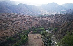
 A river valley near Presto A river valley near Presto | |
 Location of Jaime Zudáñez Province within Bolivia Location of Jaime Zudáñez Province within Bolivia | |
| Coordinates: 19°01′00″S 64°42′00″W / 19.01667°S 64.70000°W / -19.01667; -64.70000 | |
| Country | |
| Department | Chuquisaca Department |
| Capital | Zudáñez |
| Area | |
| • Total | 1,592 sq mi (4,124 km) |
| Population | |
| • Total | 42,535 |
| • Density | 27/sq mi (10/km) |
| • Ethnicities | Quechua |
| Time zone | UTC-4 (BOT) |
Jaime Zudáñez is a province in the Bolivian department of Chuquisaca. It was named after Jaime de Zudáñez, emancipation leader born in Chuquisaca in 1772.
Geography
Some of the highest mountains of the province are listed below:
- Awila Mayu
- Chullunkhäni
- Jatun Q'asa
- Llawi Q'asa
- Llusk'a Qaqa
- Muruq'uyuq
- Puka Punta
- Puka Qaqa
- Puka Urqu
- P'isaqayuq
- Qallu Urqu
- Quchayuq
- Q'illu Qisqa
- Sankha Q'asa
- Surama T'uqu
- T'ula Kimray
- Uspha T'uqu
- Wallqayuq Urqu
- Wisk'achayuq
- Yana Qaqa
- Yana Urqu
Subdivision
The province is divided into four municipalities which are further subdivided into cantons.
| Section | Municipality | Seat |
|---|---|---|
| 1st | Tacopaya Municipality or Zudáñez Municipality | Tacopaya or Zudáñez |
| 2nd | Presto Municipality | Presto |
| 3rd | Mojocoya Municipality | Mojocoya |
| 4th | Icla Municipality or Ricardo Mujia Municipality | Icla |
Places of interest
See also
References
- ^ "Icla". INE, Bolivia. Archived from the original on January 11, 2016. Retrieved April 21, 2016.
- "Zudáñez". INE, Bolivia. Retrieved April 21, 2016.
- "Presto". INE, Bolivia. Retrieved April 21, 2016.
- "Mojocoya". INE, Bolivia. Retrieved April 21, 2016.
| Capital: Sucre | ||
| Provinces |  | |
| Municipalities and seats |
| |
19°01′S 64°42′W / 19.017°S 64.700°W / -19.017; -64.700
This Chuquisaca Department location article is a stub. You can help Misplaced Pages by expanding it. |