40°51′02″N 43°56′53″E / 40.85056°N 43.94806°E / 40.85056; 43.94806
Place in Shirak, Armenia| Jajur Ջաջուռ | |
|---|---|
 Jajur Jajur | |
  | |
| Coordinates: 40°51′02″N 43°56′53″E / 40.85056°N 43.94806°E / 40.85056; 43.94806 | |
| Country | Armenia |
| Province | Shirak |
| Municipality | Akhuryan |
| Population | |
| • Total | 824 |
| Time zone | UTC+4 |
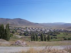
Jajur (Armenian: Ջաջուռ) is a village in the Akhuryan Municipality of the Shirak Province of Armenia. The village was established in 1828 when a lime extraction facility was established nearby.
Demographics
| Year | Pop. | ±% p.a. | ||
|---|---|---|---|---|
| 1831 | 486 | — | ||
| 1897 | 1,517 | +1.74% | ||
| 1926 | 797 | −2.19% | ||
| 1939 | 1,092 | +2.45% | ||
| 1959 | 815 | −1.45% | ||
| 1970 | 887 | +0.77% | ||
| 1979 | 742 | −1.96% | ||
| 1989 | 563 | −2.72% | ||
| 2001 | 824 | +3.23% | ||
| 2004 | 886 | +2.45% | ||
| ||||
| Source: | ||||
References
- "Հայաստանի եւ հարակից շրջանների տեղանունների բառարան, Թ.Խ. Հակոբյան, Ստ.Տ. Մելիք-Բախշյան, Հ.Խ. Բարսեղյան - Ջաջուռ". www.nayiri.com. Retrieved 2020-01-02.
- Հայաստանի Հանրապետության բնակավայրերի բառարան [Republic of Armenia settlements dictionary] (PDF) (in Armenian). Yerevan: Cadastre Committee of the Republic of Armenia. 2008. Archived from the original (PDF) on 11 March 2018.
- Jajur at GEOnet Names Server
- Report of the results of the 2001 Armenian Census, Statistical Committee of Armenia
| Capital: Gyumri | ||
| Urban settlements |  | |
| Akhuryan Municipality | ||
| Amasia Municipality | ||
| Ani Municipality | ||
| Artik Municipality | ||
| Ashotsk Municipality | ||
This article about a location in Shirak Province, Armenia is a stub. You can help Misplaced Pages by expanding it. |