| City of Jardim Olinda | |
|---|---|
 Flag Flag Seal Seal | |
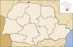
 Location of Jardim Olinda Location of Jardim Olinda | |
| Coordinates: 22°32′56″S 52°03′39″W / 22.54889°S 52.06083°W / -22.54889; -52.06083 | |
| Country | |
| Region | South |
| State | Paraná |
| Founded | December 1, 1964 |
| Government | |
| • Mayor | Fernando Jorge Siroti |
| Area | |
| • Total | 128.515 km (49.620 sq mi) |
| Population | |
| • Total | 1,320 |
| • Density | 10.96/km (28.4/sq mi) |
| Time zone | UTC−3 (BRT) |
| HDI (2000) | 0.724 – medium |
| Website | Ponta Grossa, Paraná |
Jardim Olinda is the northernmost city in the Brazilian state of Paraná. The Saran Grande waterfall, located there, is the northernmost point in the state and in all Southern Brazil.
References
- IBGE 2020
- Archived 2009-10-03 at the Wayback Machine - UNDP
This Paraná, Brazil location article is a stub. You can help Misplaced Pages by expanding it. |