| Jomda County 江达县 • འཇོ་མདའ་རྫོང་། | |
|---|---|
| County | |
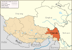
 Location of Jomda County within Tibet Location of Jomda County within Tibet | |
  | |
| Coordinates: 32°43′12″N 97°57′09″E / 32.72000°N 97.95250°E / 32.72000; 97.95250 | |
| Country | China |
| Autonomous region | Tibet |
| Prefecture-level city | Chamdo |
| County seat | Jomda |
| Area | |
| • Total | 13,159.34 km (5,080.85 sq mi) |
| Population | |
| • Total | 92,800 |
| • Density | 7.1/km (18/sq mi) |
| Time zone | UTC+8 (China Standard) |
| Website | jiangda |
| Jomda County | |||||||
|---|---|---|---|---|---|---|---|
| Chinese name | |||||||
| Simplified Chinese | 江达县 | ||||||
| Traditional Chinese | 江達縣 | ||||||
| |||||||
| Tibetan name | |||||||
| Tibetan | འཇོ་མདའ་རྫོང་། | ||||||
| |||||||
Jomda County (Tibetan: འཇོ་མདའ་རྫོང་; Chinese: 江达县) is a county of the Chamdo Prefecture in the Tibet Autonomous Region, China.
Administrative divisions
Jomda is divided in 2 towns and 11 townships.
| Name | Chinese | Hanyu Pinyin | Tibetan | Wylie | ||
|---|---|---|---|---|---|---|
| Town | ||||||
| Jomda Town | 江达镇 | Jiāngdá zhèn | འཇོ་མདའ་གྲོང་རྡལ། | ʼjo mdaʼ grong rdal | ||
| Gamtog Town | 岗托镇 | Gǎngtuō zhèn | སྐམ་ཐོག་གྲོང་རྡལ། | skam thog grong rdal | ||
| Townships | ||||||
| Kargang Township | 卡贡乡 | Kǎgòng xiāng | མཁར་སྒང་ཤང་། | mkhar sgang shang | ||
| Üpäl Township | 岩比乡 | Yánbǐ xiāng | ཨུད་དཔལ་ཤང་། | ud dpal shang | ||
| Qongkor Township | 邓柯乡 | Dèngkē xiāng | ཆོས་འཁོར་ཤང་། | chos 'khor shang | ||
| Sibda Township | 生达乡 | Shēngdá xiāng | སྲིབ་མདའ་ཤང་། | srib mda' shang | ||
| Nyaxi Township | 娘西乡 | Niángxī xiāng | ཉ་གཤིས་ཤང་། | nya gshis shang | ||
| Zigar Township | 字呷乡 | Zìgā xiāng | རྫི་སྒར་ཤང་། | rdzi sgar shang | ||
| Qu'nyido Township | 青泥洞乡 | Qīngnídòng xiāng | ཆུ་གཉེས་མདོ་ཤང་། | chu gnyes mdo shang | ||
| Woinbodoi Township | 汪布顶乡 | Wāngbùdǐng xiāng | དབོན་པོ་སྟོད་ཤང་། | dbon po stod shang | ||
| Dêrdoin Township | 德登乡 | Dédēng xiāng | གཏེར་སྟོན་ཤང་། | gter ston shang | ||
| Tongpu Township | 同普乡 | Tóngpǔ xiāng | གདོང་ཕུ་ཤང་། | gdong phu shang | ||
| Bolo Township | 波罗乡 | Tóngpǔ xiāng | སྤོ་ལོ་ཤང་། | spo lo shang | ||
Transport
See also
References
- "昌都市第七次全国人口普查主要数据公报" (in Chinese). Government of Chamdo. 2021-06-22.
- 2019年统计用区划代码 (in Chinese). National Bureau of Statistics of China. 2019. Archived from the original on 2020-09-29. Retrieved 2020-09-29.
| County-level divisions of Tibet Autonomous Region | |||||||||||||
|---|---|---|---|---|---|---|---|---|---|---|---|---|---|
| Lhasa (capital) | |||||||||||||
| Prefecture-level cities |
| ||||||||||||
| Prefecture |
| ||||||||||||
| ** Southern portions of these counties are claimed by the People's Republic of China as part of the South Tibet area, but are administered by India. | |||||||||||||
| Chamdo | ||||||
|---|---|---|---|---|---|---|
| County-level divisions |
|  | ||||
| Settlements | ||||||
| Sciences | ||||||
| Cultures | ||||||