You can help expand this article with text translated from the corresponding article in German. (February 2009) Click for important translation instructions.
|
| Königsfeld im Schwarzwald | |
|---|---|
| Municipality | |
 Coat of arms Coat of arms | |
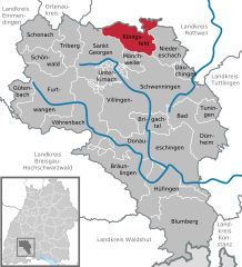
Location of Königsfeld im Schwarzwald within Schwarzwald-Baar-Kreis district
 | |
  | |
| Coordinates: 48°08′18″N 08°25′17″E / 48.13833°N 8.42139°E / 48.13833; 8.42139 | |
| Country | Germany |
| State | Baden-Württemberg |
| Admin. region | Freiburg |
| District | Schwarzwald-Baar-Kreis |
| Government | |
| • Mayor (2023–31) | Fritz Link (CDU) |
| Area | |
| • Total | 40.24 km (15.54 sq mi) |
| Elevation | 769 m (2,523 ft) |
| Population | |
| • Total | 6,111 |
| • Density | 150/km (390/sq mi) |
| Time zone | UTC+01:00 (CET) |
| • Summer (DST) | UTC+02:00 (CEST) |
| Postal codes | 78126 |
| Dialling codes | 07725 |
| Vehicle registration | VS |
| Website | www.koenigsfeld.de |
Königsfeld im Schwarzwald (Low Alemannic: Kinnigsfeld) is a town in the district of Schwarzwald-Baar in Baden-Württemberg in Germany. It is the northernmost town of the district Schwarzwald Baar. Königsfeld has six boroughs (Königsfeld, Neuhausen, Erdmannsweiler, Buchenberg, Burgberg and Weiler). Founded in 1807, it is a centre of the Moravian Church. Until after the Second World War, most of the town's inhabitants continued to be Moravians and the Vorsteher (congregational business manager) of the Congregation also served as de facto Mayor of the town. After the war, great numbers of refugees from former eastern provinces of Germany settled in the town. Königsfeld is on several major bus lines, the next train stations are in St. Georgen and Villingen-Schwenningen. Regional bus lines connect Königsfeld to these towns. Until 1981 it was served by the train station Peterzell-Königsfeld, 5 km outside Königsfeld. Königsfeld is the seat of several boarding schools and a classical Gymnasium/High School/Public School and a School for Home Economics, all operated by the Moravian Church. Humanitarian Albert Schweizer maintained a home in Königsfeld because his wife could not live in Lambaréné due to her health. His home in Königsfeld is now a museum. There is also a small museum dealing with the history of the town.

Demographics
Population development:
|
References
- Bürgermeisterwahl Königsfeld im Schwarzwald 2023, Staatsanzeiger. Retrieved 13 June 2024.
- "Bevölkerung nach Nationalität und Geschlecht am 31. Dezember 2022" [Population by nationality and sex as of December 31, 2022] (CSV) (in German). Statistisches Landesamt Baden-Württemberg. June 2023.
- "Königsfeld im Schwarzwald (Schwarzwald-Baar-Kreis, Baden-Württemberg, Deutschland) - Einwohnerzahlen, Grafiken, Karte, Lage, Wetter und Web-Informationen". www.citypopulation.de. Retrieved 2023-05-23.
This Schwarzwald-Baar location article is a stub. You can help Misplaced Pages by expanding it. |
