| Kalumburu Road Western Australia | |
|---|---|
 | |
| Kalumburu Road (blue and white) | |
| General information | |
| Type | Rural road |
| Length | 267 km (166 mi) |
| Major junctions | |
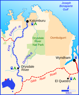
The Kalumburu Road in the Kimberley region of Western Australia is a 267 kilometre unsealed road that connects the Gibb River Road to the Aboriginal community of Kalumburu on the coast via the Mitchell Plateau. The road, which often becomes inaccessible during the wet season, is suitable for four-wheel drive traffic and facilities are limited to supplies available at the roadhouse at the Drysdale River Station. Kalumburu Road runs north from the Gibb River Road, which it intersects approximately 250 km west of Kununurra. It also provides visitors access to Mitchell Falls.
See also
References
- "Gibb River Road, Kalumburu & the Mitchell Plateau". Australia's Northwest. Retrieved 7 September 2008.
- Hema, Maps (2007). Australia Road and 4WD Atlas (Map). Eight Mile Plains Queensland: Hema Maps. p. 89. ISBN 978-1-86500-456-3.
- O'Byrne, Denis; Rob Van Driesum; Paul Harding; Pete Cruttenden; Mic Looby (1988). Lonely Planet Outback Australia. p. 321. ISBN 1-86450-187-1.
- "The Gibb River Road". Open Road. NRMA. Archived from the original on 19 July 2008. Retrieved 7 September 2008.
- Gebicki, Michael (14 May 2005). "Discovering Our Glorious Frontier". The Sun-Herald. The Age. Retrieved 7 September 2008.
This Western Australian road or road transport-related article is a stub. You can help Misplaced Pages by expanding it. |