Strait in Russia
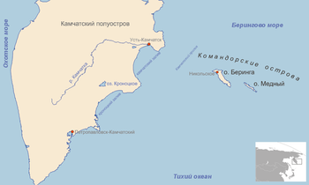
Location map of Kamchatka Strait between Kamchatka Peninsula and Bering Island . Kamchatka Strait (Russian : Камчатский пролив) is a 191 km-wide strait off the mainland coast of Kamchatka Krai in the Russian Far East .
Geography
It separates the mainland on Kamchatka Peninsula from Bering Island , one of the Commander Islands group.
Kamchatka Strait connects the Bering Sea in the north with the Pacific Ocean in the south.
55°39′N 164°33′E / 55.650°N 164.550°E / 55.650; 164.550
Categories :
Kamchatka Strait
Add topic
Text is available under the Creative Commons Attribution-ShareAlike License. Additional terms may apply.
**DISCLAIMER** We are not affiliated with Wikipedia, and Cloudflare.
The information presented on this site is for general informational purposes only and does not constitute medical advice.
You should always have a personal consultation with a healthcare professional before making changes to your diet, medication, or exercise routine.
AI helps with the correspondence in our chat.
We participate in an affiliate program. If you buy something through a link, we may earn a commission 💕
↑
