| This article needs additional citations for verification. Please help improve this article by adding citations to reliable sources. Unsourced material may be challenged and removed. Find sources: "Khoda Afarin County" – news · newspapers · books · scholar · JSTOR (May 2024) (Learn how and when to remove this message) |
County in East Azerbaijan, Iran
| Khoda Afarin County Persian: شهرستان خداآفرین | |
|---|---|
| County | |
 Construction boom in previously abandoned villages Construction boom in previously abandoned villages | |
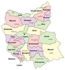
 Location of Khoda Afarin County in East Azerbaijan province (top, yellow) Location of Khoda Afarin County in East Azerbaijan province (top, yellow) | |
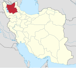
 Location of East Azerbaijan province in Iran Location of East Azerbaijan province in Iran | |
| Coordinates: 39°05′N 46°56′E / 39.083°N 46.933°E / 39.083; 46.933 | |
| Country | |
| Province | East Azerbaijan |
| Capital | Khomarlu |
| Districts | Central, Garamduz, Minjavan |
| Population | |
| • Total | 32,995 |
| Time zone | UTC+3:30 (IRST) |
Khoda Afarin (Persian: شهرستان خداآفرین) is a county in East Azerbaijan province of Iran. The city of Khomarlu is the capital of the Khoda Afarin.
History
Before the Islamic Revolution, the city of Khomarlu was merely a village which was distinguished from other villages for housing the headquarters of Royal Gendarmery. The notary office was located in Abbasabad village and operated by a cleric, who also acted as the spiritual authority of the whole district.
After the 2006 National Census, Khoda Afarin District was separated from Kaleybar County in the establishment of Khoda Afarin County, which was divided into three districts and seven rural districts, with Khomarlu as its capital and only city.
Demographics
Language
The spoken language of a vast majority of the inhabitants is modern Azeri Turkish, which has much similarity to Turkmeni, Afshar and the Anatolian Turkish.
The ancient Indo-European, Iranic language of the province before its turkification, survives in the Tati language, particularly in its Karingani dialect. In addition to the large village of Karingan, the villages of Chay Kandi, Kalasor, Khoynarood, and Arazin also are the last speakers of the old native language of Azerbaijan.
The mountainous terrain, shepherding and cultivation of hillsides possess the isolating features for the development of a sophisticated whistled language. The inhabitants of the region employ the fingered whistle format for long range communication. More importantly, the majority of males are able, and perhaps addicted, to masterfully mimic the melodic sounds of musical instruments using fingerless whistle. Melodic whistling, indeed, appears to be a private version of the Ashug music for personal satisfaction.
Population
At the time of the 2011 census, the county's population was 34,977 people in 9,169 households. The 2016 census measured the population of the county as 32,995 in 10,196 households.
Administrative divisions
Khoda Afarin County's population history and administrative structure over two consecutive censuses are shown in the following table.
| Administrative Divisions | 2011 | 2016 |
|---|---|---|
| Central District | 9,489 | 8,531 |
| Bastamlu RD | 5,407 | 4,561 |
| Keyvan RD | 2,423 | 2,068 |
| Khomarlu (city) | 1,659 | 1,902 |
| Garamduz District | 12,964 | 12,544 |
| Garamduz-e Gharbi RD | 8,826 | 8,308 |
| Garamduz-e Sharqi RD | 4,138 | 4,236 |
| Minjavan District | 12,524 | 11,920 |
| Dizmar-e Sharqi RD | 3,097 | 2,760 |
| Minjavan-e Gharbi RD | 4,214 | 4,094 |
| Minjavan-e Sharqi RD | 5,213 | 5,066 |
| Total | 34,977 | 32,995 |
| RD = Rural District | ||

Before the Islamic Revolution of 1978, then a district of Ahar County, had a dynamic economy; the surplus agricultural products from fertile farmlands along Aras were exported to Ahar, and on the lush uplands large herds of sheep were a common sight. Of course, since the turbulent days of Azerbaijan Democratic Government, some residents were travelling to Tehran or Tabriz for seasonal work on construction projects, and by the late 1970s some of these migrant workers were established contractors.
Accordingly, the majority of active male population was spending half of the year in cities. The Islamic Revolution drastically changed social order. In the 1978–1979 period many of the migrant workers in Tehran constructed illegal dwellings on government lands at the North-East of Tehran and moved their families to the city. During the second big migration wave of the 1990s, most villages of the county were evacuated and residents settled in the shanty-towns at the South-West of Tehran. In recent years, some expatriates have returned and constructed decent houses. The county is already experiencing a construction boom. This has rapidly increased demand for construction workers. Moreover, the capital inflow to the county in anticipation of potential boom in Eco-tourism has resulted in launching many projects related to hotels and campgrounds.
Historical sites

- Vinaq. An old mansion in Vinaq village, which was built by Tomanies in 1907. The mansion is similar to the Aynaloo mansion in architecture.
- Baba Seyfaddin pilgrimage site near Garmanab village. The village is also a significantly important place as in last 150 years it has been inhabited by Armenians, followers of Yarsan religion and Shia Islam, respectively. The graveyard of Armenians has been preserved and the writings on the grave stones may provide important clues to the history of Arasbaran.
- Khoda Afarin bridges. Two bridges on Aras river are located near Khomarlu. One bridge is badly damaged and the other is still usable for pedestrians. The later bridge is 160 m in length.
- Alherd village. This historical village has an ancient graveyard with tombstones, unusually, engraved with ornamental figures. It is possible that archaeological studies may unravel significant historical evidences.
Ashugh music
The county has been known as the epicenter of Arasbaran school of Ashugh music. The mountainous terrain, and the socio-cultural upheavals of the past two centuries have given a characteristic melancholic feature to the songs composed by the rebel-poets originating from the region. A revealing example is a song which was composed by Bahman Zamani following the tragic drowning of Samad Behrangi in Aras.
See also
Notes
- Formerly Garamduz Rural District
References
- OpenStreetMap contributors (4 September 2024). "Khoda Afarin County" (Map). OpenStreetMap (in Persian). Retrieved 4 September 2024.
- ^ Census of the Islamic Republic of Iran, 1395 (2016): East Azerbaijan Province. amar.org.ir (Report) (in Persian). The Statistical Center of Iran. Archived from the original (Excel) on 13 November 2020. Retrieved 19 December 2022.
- ^ Rahimi, Mohammad Reza (c. 2022) . Letter of approval regarding country divisions in Kaleybar County. qavanin.ir (Report) (in Persian). Ministry of the Interior, Council of Ministers. Proposal 1/4/42/111195. Archived from the original on 26 September 2022. Retrieved 20 November 2023 – via Laws and Regulations Portal of the Islamic Republic of Iran.
- Concise Encyclopedia of Languages of the World, 2010, Elsevier, p. 110-113
- James Stuart Olson, Lee Brigance Pappas, Nicholas Charles Pappas (Editors), An Ethnohistorical Dictionary of the Russian and Soviet Empires 1994, p. 623
- E. Yarshater, Iranian Languages and Texts from Iran and Turan, edited by Maria Macuch, Mauro Maggi, Werner Sundermann, 2007, page 443.
- J.Meyer, Bioacoustics of human whistled languages: an alternative approach to the cognitive processes of language, Anais da Academia Brasileira de Ciências,76, 405-412, (2004)
- ^ Census of the Islamic Republic of Iran, 1390 (2011): East Azerbaijan Province. irandataportal.syr.edu (Report) (in Persian). The Statistical Center of Iran. Archived from the original (Excel) on 16 January 2023. Retrieved 19 December 2022 – via Iran Data Portal, Syracuse University.
- "Panoramio is no longer available".
[REDACTED] Media related to Khoda Afarin County at Wikimedia Commons
| Capital | |||||||||||||||||||||||||||||||
|---|---|---|---|---|---|---|---|---|---|---|---|---|---|---|---|---|---|---|---|---|---|---|---|---|---|---|---|---|---|---|---|
| Districts |
| ||||||||||||||||||||||||||||||
